Cantagrillo-Casalguidi night lights from space
Night Light of Cantagrillo-Casalguidi (Tuscany) from space (Italy) Src. Average luminocity for 10x10km area is 36.9111% and for 50x50km: 31.2075%.
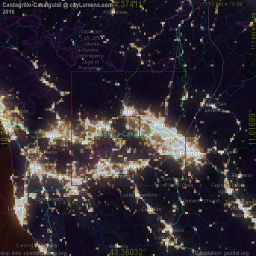
Analysis of Cantagrillo-Casalguidi night lights 2016
Square area 10x10 km:
 2.54%
2.54%90-99
1.75%80-89
1.43%70-79
4.13%60-69
9.68%50-59
8.89%40-49
12.22%30-39
6.19%20-29
16.83%10-19
36.35%0-9
0%Square area 50x50 km:
6.18%90-99
6.3%80-89
2.16%70-79
3.09%60-69
3.96%50-59
4.33%40-49
5%30-39
4.64%20-29
12.38%10-19
16.72%0-9
35.26%Clear (daylight) street map image can be seen on geolist.org.
Map coordinates:
44° 22' 26.8" North, 10° 12' 38.7" East
43° 52' 9.7" North, 10° 54' 49.9" East
43° 21' 37.2" North, 11° 37' 1.2" East
Some cities around Cantagrillo-Casalguidi sort by population:
• Pistoia
6.9 km =4.3 mi,  6°
6°
• Agliana
8.2 km =5.1 mi,  63°
63°
• Monsummano Terme
8.1 km =5 mi,  268°
268°
• Quarrata
5.7 km =3.5 mi,  114°
114°
• Pieve a Nievole
9.2 km =5.7 mi,  278°
278°
• Montale
11 km =6.8 mi,  48°
48°
• Seano
9.6 km =6 mi,  116°
116°
• Lamporecchio
7.5 km =4.7 mi,  203°
203°
6543990 (p: 6,532)
Sources (retrieved 2019-11-25):
» Earth at Night: Flat Maps 2012, 2016