Montagnana night lights from space
Night Light of Montagnana (Veneto) from space (Italy) Src. Average luminocity for 10x10km area is 25.4924% and for 50x50km: 28.7031%.
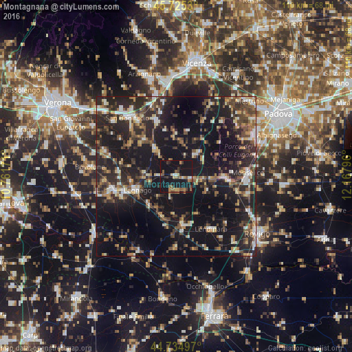
Analysis of Montagnana night lights 2016
Square area 10x10 km:
 1.36%
1.36%90-99
1.67%80-89
2.27%70-79
3.18%60-69
4.39%50-59
6.36%40-49
3.18%30-39
3.33%20-29
4.39%10-19
61.21%0-9
8.64%Square area 50x50 km:
2.62%90-99
3.84%80-89
2.84%70-79
2.81%60-69
3.39%50-59
4.32%40-49
5.71%30-39
5.6%20-29
13.38%10-19
32.41%0-9
23.08%Clear (daylight) street map image can be seen on geolist.org.
Map coordinates:
45° 43' 31.1" North, 10° 45' 42.2" East
45° 13' 56.2" North, 11° 27' 53.4" East
44° 44' 5.9" North, 12° 10' 4.7" East
Some cities around Montagnana sort by population:
• Legnago
13.4 km =8.3 mi,  251°
251°
• Este
15.6 km =9.7 mi,  93°
93°
• Cerea
20 km =12.4 mi,  256°
256°
• Lonigo
18.2 km =11.3 mi,  339°
339°
• Noventa Vicentina
9.5 km =5.9 mi,  43°
43°
• Lendinara
19.8 km =12.3 mi,  146°
146°
• Badia Polesine
15.4 km =9.6 mi,  171°
171°
• Ospedaletto Euganeo
11 km =6.8 mi,  98°
98°
3173110 (p: 8,000)
Sources (retrieved 2019-11-25):
» Earth at Night: Flat Maps 2012, 2016