Badia Polesine night lights from space
Night Light of Badia Polesine (Veneto) from space (Italy) Src. Average luminocity for 10x10km area is 27.4015% and for 50x50km: 22.703%.
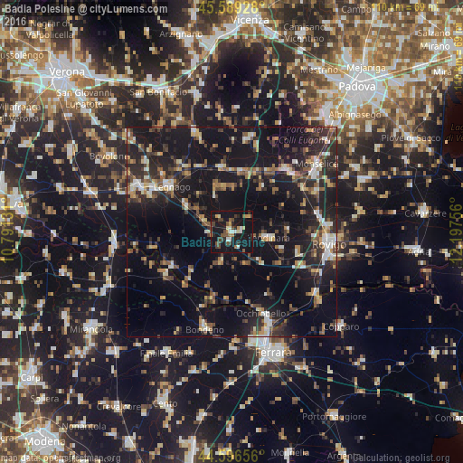
Analysis of Badia Polesine night lights 2016
Square area 10x10 km:
 1.52%
1.52%90-99
4.7%80-89
1.67%70-79
3.03%60-69
2.73%50-59
3.94%40-49
7.88%30-39
3.94%20-29
4.39%10-19
55.91%0-9
10.3%Square area 50x50 km:
1.91%90-99
2.76%80-89
2.28%70-79
2.12%60-69
2.58%50-59
3.39%40-49
4.14%30-39
4.06%20-29
8.8%10-19
28.46%0-9
39.5%Clear (daylight) street map image can be seen on geolist.org.
Map coordinates:
45° 35' 21.4" North, 10° 47' 28.7" East
45° 5' 42.3" North, 11° 29' 39.9" East
44° 35' 47.6" North, 12° 11' 51.2" East
Some cities around Badia Polesine sort by population:
• Legnago
18.6 km =11.6 mi,  306°
306°
• Este
19.5 km =12.1 mi,  42°
42°
• Santa Maria Maddalena
23.2 km =14.4 mi,  157°
157°
• Montagnana
15.4 km =9.6 mi,  351°
351°
• Noventa Vicentina
22.6 km =14 mi,  10°
10°
• Lendinara
8.6 km =5.3 mi,  98°
98°
• Solesino
21.9 km =13.6 mi,  64°
64°
• Ospedaletto Euganeo
16.2 km =10.1 mi,  31°
31°
3182576 (p: 6,940)
Sources (retrieved 2019-11-25):
» Earth at Night: Flat Maps 2012, 2016