Lonigo night lights from space
Night Light of Lonigo (Veneto) from space (Italy) Src. Average luminocity for 10x10km area is 37.9667% and for 50x50km: 34.2745%.
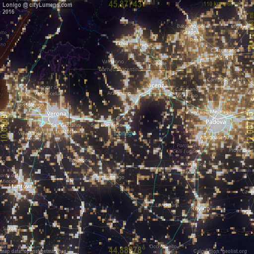
Analysis of Lonigo night lights 2016
Square area 10x10 km:
 3.65%
3.65%90-99
5.87%80-89
3.81%70-79
2.54%60-69
2.38%50-59
6.03%40-49
10.79%30-39
8.1%20-29
30%10-19
26.51%0-9
0.32%Square area 50x50 km:
3.8%90-99
5.24%80-89
3.44%70-79
3.44%60-69
4.14%50-59
5.72%40-49
6.69%30-39
6.82%20-29
17.41%10-19
28.61%0-9
14.69%Clear (daylight) street map image can be seen on geolist.org.
Map coordinates:
45° 52' 38.7" North, 10° 40' 51.2" East
45° 23' 8.7" North, 11° 23' 2.5" East
44° 53' 23.2" North, 12° 5' 13.7" East
Some cities around Lonigo sort by population:
• Arzignano
15.4 km =9.6 mi,  345°
345°
• Montecchio Maggiore-Alte Ceccato
13.3 km =8.3 mi,  9°
9°
• San Bonifacio
8.7 km =5.4 mi,  277°
277°
• Altavilla Vicentina
15.6 km =9.7 mi,  24°
24°
• Noventa Vicentina
16.4 km =10.2 mi,  128°
128°
• Monteforte d'Alpone
8.7 km =5.4 mi,  296°
296°
• Montebello Vicentino
8.2 km =5.1 mi,  359°
359°
• Soave
11.4 km =7.1 mi,  289°
289°
3174587 (p: 12,110)
Sources (retrieved 2019-11-25):
» Earth at Night: Flat Maps 2012, 2016