Este night lights from space
Night Light of Este (Veneto) from space (Italy) Src. Average luminocity for 10x10km area is 33.5788% and for 50x50km: 32.4267%.
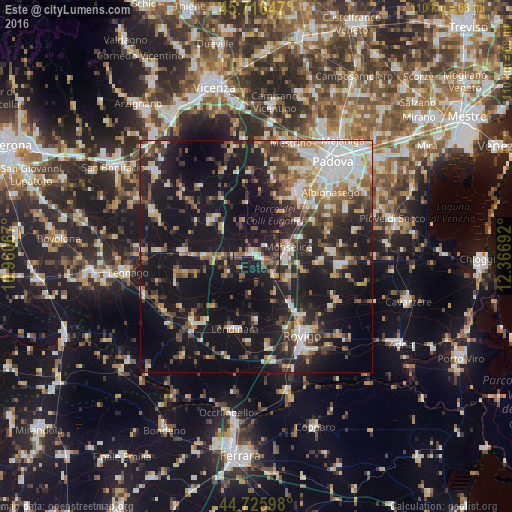
Analysis of Este night lights 2016
Square area 10x10 km:
 1.82%
1.82%90-99
3.48%80-89
4.7%70-79
2.42%60-69
5.45%50-59
7.73%40-49
5.76%30-39
5.3%20-29
15.61%10-19
46.97%0-9
0.76%Square area 50x50 km:
4.62%90-99
5.65%80-89
3.32%70-79
3.37%60-69
3.63%50-59
4.48%40-49
5.58%30-39
5.34%20-29
10.4%10-19
31.37%0-9
22.24%Clear (daylight) street map image can be seen on geolist.org.
Map coordinates:
45° 42' 59.3" North, 10° 57' 38.4" East
45° 13' 24.2" North, 11° 39' 49.6" East
44° 43' 33.5" North, 12° 22' 0.9" East
Some cities around Este sort by population:
• Monselice
7 km =4.3 mi,  75°
75°
• Montegrotto Terme
15.4 km =9.6 mi,  38°
38°
• Carrara San Giorgio
14.3 km =8.9 mi,  57°
57°
• Montagnana
15.6 km =9.7 mi,  273°
273°
• Noventa Vicentina
12 km =7.5 mi,  311°
311°
• Solesino
8.1 km =5 mi,  127°
127°
• Ospedaletto Euganeo
4.8 km =3 mi,  263°
263°
• Torreglia
13.8 km =8.6 mi,  24°
24°
3177337 (p: 16,963)
Sources (retrieved 2019-11-25):
» Earth at Night: Flat Maps 2012, 2016