Calcinate night lights from space
Night Light of Calcinate (Lombardy) from space (Italy) Src. Average luminocity for 10x10km area is 71.4606% and for 50x50km: 48.1337%.
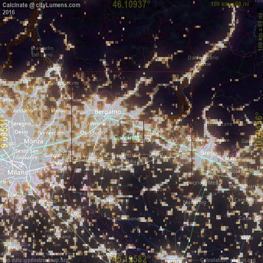
Analysis of Calcinate night lights 2016
Square area 10x10 km:
 16.36%
90-99
18.03%80-89
9.24%70-79
3.79%60-69
13.48%50-59
13.94%40-49
18.48%30-39
6.67%20-29
0%10-19
0%0-9
0%Square area 50x50 km:
9.21%90-99
10.32%80-89
4.49%70-79
5.17%60-69
7.2%50-59
7.82%40-49
7.14%30-39
8.56%20-29
13.74%10-19
17.09%0-9
9.25%Clear (daylight) street map image can be seen on geolist.org.
Map coordinates:
46° 6' 33.7" North, 9° 5' 43.1" East
45° 37' 11.1" North, 9° 47' 54.3" East
45° 7' 33" North, 10° 30' 5.6" East
Some cities around Calcinate sort by population:
• Castelli Calepio
6.8 km =4.2 mi,  96°
96°
• Martinengo
5.8 km =3.6 mi,  204°
204°
• Grumello del Monte
6.2 km =3.9 mi,  73°
73°
• Ghisalba
4.3 km =2.7 mi,  227°
227°
• Bolgare
1.9 km =1.2 mi,  40°
40°
• Chiuduno
5.3 km =3.3 mi,  49°
49°
• Palosco
4.5 km =2.8 mi,  138°
138°
• Brusaporto
6.5 km =4 mi,  332°
332°
3181224 (p: 5,152)
Sources (retrieved 2019-11-25):
» Earth at Night: Flat Maps 2012, 2016