Pontoglio night lights from space
Night Light of Pontoglio (Lombardy) from space (Italy) Src. Average luminocity for 10x10km area is 51.7409% and for 50x50km: 48.1817%.
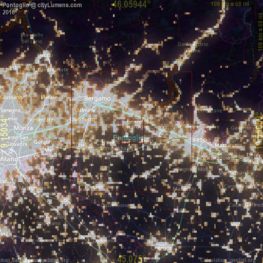
Analysis of Pontoglio night lights 2016
Square area 10x10 km:
 6.06%
6.06%90-99
10.76%80-89
4.85%70-79
2.73%60-69
7.88%50-59
11.21%40-49
12.27%30-39
16.82%20-29
27.12%10-19
0.3%0-9
0%Square area 50x50 km:
9.45%90-99
10.51%80-89
4.41%70-79
4.94%60-69
6.87%50-59
7.62%40-49
7.06%30-39
8.5%20-29
15.25%10-19
16.11%0-9
9.29%Clear (daylight) street map image can be seen on geolist.org.
Map coordinates:
46° 3' 34" North, 9° 9' 1.2" East
45° 34' 9.8" North, 9° 51' 12.5" East
45° 4' 30" North, 10° 33' 23.7" East
Some cities around Pontoglio sort by population:
• Palazzolo sull'Oglio
4 km =2.5 mi,  40°
40°
• Chiari
6.7 km =4.2 mi,  121°
121°
• Castelli Calepio
5.5 km =3.4 mi,  27°
27°
• Martinengo
6.7 km =4.2 mi,  272°
272°
• Cologne
7 km =4.3 mi,  81°
81°
• Grumello del Monte
7.5 km =4.7 mi,  13°
13°
• Palosco
2.6 km =1.6 mi,  329°
329°
• Calcinate
7 km =4.3 mi,  322°
322°
6535202 (p: 6,153)
Sources (retrieved 2019-11-25):
» Earth at Night: Flat Maps 2012, 2016