Bolgare night lights from space
Night Light of Bolgare (Lombardy) from space (Italy) Src. Average luminocity for 10x10km area is 73.8924% and for 50x50km: 47.0855%.
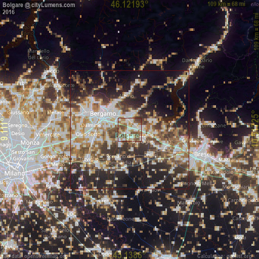
Analysis of Bolgare night lights 2016
Square area 10x10 km:
 17.27%
90-99
19.85%80-89
9.24%70-79
5%60-69
15.15%50-59
14.39%40-49
14.7%30-39
4.39%20-29
0%10-19
0%0-9
0%Square area 50x50 km:
9.01%90-99
10%80-89
4.4%70-79
4.98%60-69
6.99%50-59
7.74%40-49
7.06%30-39
8.35%20-29
13.38%10-19
16.72%0-9
11.35%Clear (daylight) street map image can be seen on geolist.org.
Map coordinates:
46° 7' 18.9" North, 9° 6' 39.6" East
45° 37' 56.7" North, 9° 48' 50.8" East
45° 8' 19" North, 10° 31' 2.1" East
Some cities around Bolgare sort by population:
• Palazzolo sull'Oglio
6.9 km =4.3 mi,  125°
125°
• Castelli Calepio
5.9 km =3.7 mi,  111°
111°
• Grumello del Monte
4.8 km =3 mi,  86°
86°
• Ghisalba
6.2 km =3.9 mi,  225°
225°
• Chiuduno
3.4 km =2.1 mi,  53°
53°
• Palosco
5.1 km =3.2 mi,  160°
160°
• Brusaporto
6 km =3.7 mi,  316°
316°
• Calcinate
1.9 km =1.2 mi,  220°
220°
6535162 (p: 5,440)
Sources (retrieved 2019-11-25):
» Earth at Night: Flat Maps 2012, 2016