Locorotondo night lights from space
Night Light of Locorotondo (Apulia) from space (Italy) Src. Average luminocity for 10x10km area is 31.7435% and for 50x50km: 18.7192%.
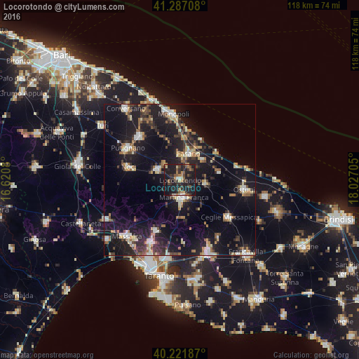
Analysis of Locorotondo night lights 2016
Square area 10x10 km:
 1.46%
1.46%90-99
1.14%80-89
3.57%70-79
3.41%60-69
5.84%50-59
5.36%40-49
5.68%30-39
9.09%20-29
21.43%10-19
40.91%0-9
2.11%Square area 50x50 km:
1.79%90-99
2.46%80-89
2.1%70-79
1.76%60-69
2.45%50-59
2.37%40-49
2.39%30-39
3.23%20-29
6.64%10-19
22.05%0-9
52.75%Clear (daylight) street map image can be seen on geolist.org.
Map coordinates:
41° 17' 13.5" North, 16° 37' 14.9" East
40° 45' 23.8" North, 17° 19' 26.1" East
40° 13' 18.7" North, 18° 1' 37.4" East
Some cities around Locorotondo sort by population:
• Martina Franca
6 km =3.7 mi,  168°
168°
• Putignano
20 km =12.4 mi,  301°
301°
• Fasano
9.4 km =5.8 mi,  18°
18°
• Noci
17.1 km =10.6 mi,  283°
283°
• Castellana
19.6 km =12.2 mi,  317°
317°
• Crispiano
18.6 km =11.6 mi,  204°
204°
• Alberobello
8 km =5 mi,  292°
292°
• Cisternino
8.7 km =5.4 mi,  99°
99°
3174641 (p: 7,471)
Sources (retrieved 2019-11-25):
» Earth at Night: Flat Maps 2012, 2016