Martina Franca night lights from space
Night Light of Martina Franca (Apulia) from space (Italy) Src. Average luminocity for 10x10km area is 29.4399% and for 50x50km: 20.77%.
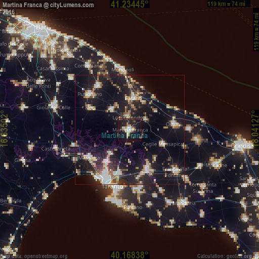

Analysis of Martina Franca night lights 2016
Square area 10x10 km:
 3.08%
3.08%90-99
5.36%80-89
3.41%70-79
2.11%60-69
3.73%50-59
2.11%40-49
3.41%30-39
4.87%20-29
13.47%10-19
43.18%0-9
15.26%Square area 50x50 km:
2.34%90-99
3.12%80-89
2.05%70-79
1.93%60-69
2.74%50-59
2.63%40-49
2.39%30-39
3.42%20-29
7.47%10-19
23.44%0-9
48.46%Clear (daylight) street map image can be seen on geolist.org.
Map coordinates:
41° 14' 4" North, 16° 38' 6.1" East
40° 42' 12.8" North, 17° 20' 17.3" East
40° 10' 6.2" North, 18° 2' 28.6" East
Some cities around Martina Franca sort by population:
• Ostuni
20.3 km =12.6 mi,  81°
81°
• Fasano
14.9 km =9.3 mi,  7°
7°
• Ceglie Messapica
16.3 km =10.1 mi,  112°
112°
• Crispiano
14.2 km =8.8 mi,  218°
218°
• Alberobello
12.4 km =7.7 mi,  316°
316°
• Locorotondo
6 km =3.7 mi,  348°
348°
• Villa Castelli
17.7 km =11 mi,  139°
139°
• Cisternino
8.6 km =5.3 mi,  59°
59°
3173841 (p: 37,685)
Sources (retrieved 2019-11-25):
» Earth at Night: Flat Maps 2012, 2016