Lignano Sabbiadoro night lights from space
Night Light of Lignano Sabbiadoro (Friuli Venezia Giulia) from space (Italy) Src. Average luminocity for 10x10km area is 26.8333% and for 50x50km: 10.3121%.
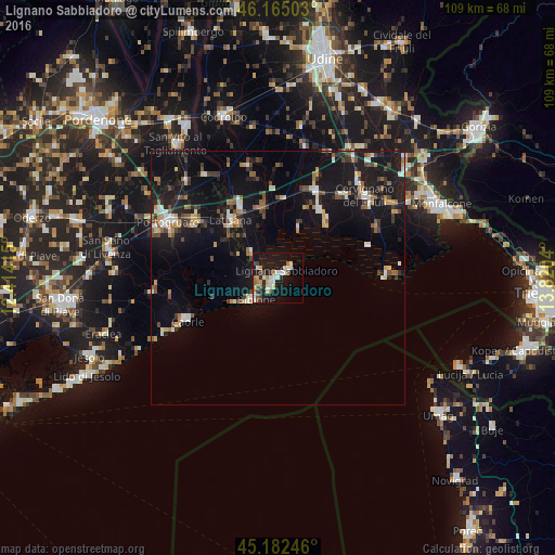
Analysis of Lignano Sabbiadoro night lights 2016
Square area 10x10 km:
 5.76%
5.76%90-99
3.64%80-89
2.58%70-79
3.79%60-69
2.73%50-59
3.18%40-49
3.48%30-39
3.18%20-29
2.12%10-19
31.52%0-9
38.03%Square area 50x50 km:
0.98%90-99
1.46%80-89
0.76%70-79
1.07%60-69
1.09%50-59
1.52%40-49
1.71%30-39
1.34%20-29
2.07%10-19
13.53%0-9
74.48%Clear (daylight) street map image can be seen on geolist.org.
Map coordinates:
46° 9' 54.1" North, 12° 24' 50.9" East
45° 40' 33.2" North, 13° 7' 2.2" East
45° 10' 56.9" North, 13° 49' 13.4" East
Some cities around Lignano Sabbiadoro sort by population:
• Portogruaro
24.4 km =15.2 mi,  298°
298°
• Cervignano del Friuli
23.6 km =14.7 mi,  46°
46°
• Latisana
13.4 km =8.3 mi,  320°
320°
• Concordia Sagittaria
24.7 km =15.3 mi,  292°
292°
• Caorle
20.7 km =12.9 mi,  244°
244°
• Staranzano
33 km =20.5 mi,  64°
64°
• Grado
22.2 km =13.8 mi,  89°
89°
• San Giorgio di Nogaro
18.3 km =11.4 mi,  23°
23°
3174729 (p: 5,837)
Sources (retrieved 2019-11-25):
» Earth at Night: Flat Maps 2012, 2016