Caorle night lights from space
Night Light of Caorle (Veneto) from space (Italy) Src. Average luminocity for 10x10km area is 13.1621% and for 50x50km: 12.9716%.
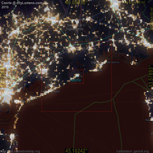
Analysis of Caorle night lights 2016
Square area 10x10 km:
 1.97%
1.97%90-99
3.18%80-89
0.45%70-79
1.67%60-69
1.52%50-59
0.91%40-49
1.52%30-39
0.61%20-29
1.06%10-19
2.27%0-9
84.85%Square area 50x50 km:
1.46%90-99
2.26%80-89
1.07%70-79
1.41%60-69
1.21%50-59
1.76%40-49
1.97%30-39
1.24%20-29
4.04%10-19
15.82%0-9
67.75%Clear (daylight) street map image can be seen on geolist.org.
Map coordinates:
46° 5' 11" North, 12° 10' 21.6" East
45° 35' 47.6" North, 12° 52' 32.9" East
45° 6' 8.7" North, 13° 34' 44.1" East
Some cities around Caorle sort by population:
• Portogruaro
20.7 km =12.9 mi,  352°
352°
• Lido di Jesolo
20.4 km =12.7 mi,  240°
240°
• Latisana
21.6 km =13.4 mi,  27°
27°
• Concordia Sagittaria
18.7 km =11.6 mi, 347°
• Iesolo
19.3 km =12 mi,  248°
248°
• San Stino di Livenza
20.4 km =12.7 mi,  314°
314°
• Lignano Sabbiadoro
20.7 km =12.9 mi,  64°
64°
• Ceggia
20.8 km =12.9 mi,  298°
298°
3180749 (p: 7,511)
Sources (retrieved 2019-11-25):
» Earth at Night: Flat Maps 2012, 2016