Oria night lights from space
Night Light of Oria (Apulia) from space (Italy) Src. Average luminocity for 10x10km area is 25.2415% and for 50x50km: 18.7956%.
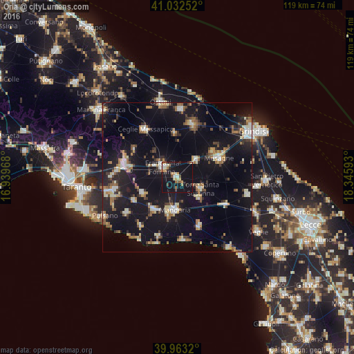
Analysis of Oria night lights 2016
Square area 10x10 km:
 2.21%
2.21%90-99
4.08%80-89
1.7%70-79
3.4%60-69
5.61%50-59
2.21%40-49
2.21%30-39
1.19%20-29
1.53%10-19
56.63%0-9
19.22%Square area 50x50 km:
1.81%90-99
2.7%80-89
1.98%70-79
1.69%60-69
2.74%50-59
2.18%40-49
1.99%30-39
2.26%20-29
4.36%10-19
25.99%0-9
52.31%Clear (daylight) street map image can be seen on geolist.org.
Map coordinates:
41° 1' 57.1" North, 16° 56' 22.8" East
40° 29' 60" North, 17° 38' 34.1" East
39° 57' 47.5" North, 18° 20' 45.3" East
Some cities around Oria sort by population:
• Francavilla Fontana
6 km =3.7 mi,  305°
305°
• Manduria
11.2 km =7 mi,  182°
182°
• Sava
13.3 km =8.3 mi,  214°
214°
• Latiano
8.5 km =5.3 mi,  48°
48°
• Torre Santa Susanna
8.9 km =5.5 mi,  113°
113°
• San Marzano di San Giuseppe
12.8 km =8 mi,  246°
246°
• Erchie
10.6 km =6.6 mi,  131°
131°
• San Michele Salentino
14.7 km =9.1 mi,  356°
356°
3171961 (p: 14,715)
Sources (retrieved 2019-11-25):
» Earth at Night: Flat Maps 2012, 2016