Scanzo-Rosciate night lights from space
Night Light of Scanzo-Rosciate (Lombardy) from space (Italy) Src. Average luminocity for 10x10km area is 76.7076% and for 50x50km: 45.3884%.
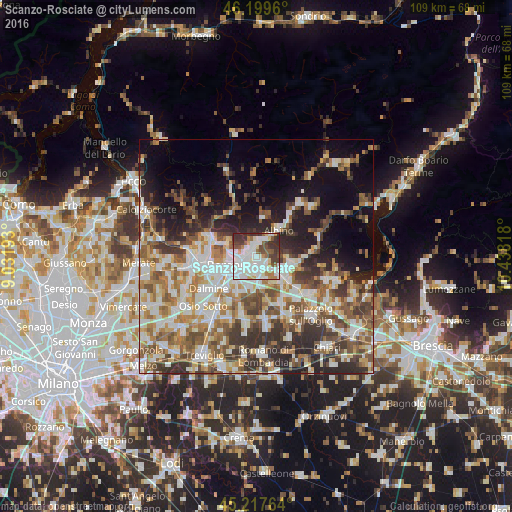
Analysis of Scanzo-Rosciate night lights 2016
Square area 10x10 km:
 31.97%
90-99
21.06%80-89
4.39%70-79
5.91%60-69
5.15%50-59
7.88%40-49
6.67%30-39
12.88%20-29
4.09%10-19
0%0-9
0%Square area 50x50 km:
9.08%90-99
9.97%80-89
4.48%70-79
5.29%60-69
7%50-59
7.68%40-49
7.02%30-39
7.56%20-29
8.69%10-19
11.05%0-9
22.16%Clear (daylight) street map image can be seen on geolist.org.
Map coordinates:
46° 11' 58.6" North, 9° 1' 54.9" East
45° 42' 38.8" North, 9° 44' 6.2" East
45° 13' 3.5" North, 10° 26' 17.4" East
Some cities around Scanzo-Rosciate sort by population:
• Seriate
2.9 km =1.8 mi,  195°
195°
• Alzano Lombardo
3 km =1.9 mi,  346°
346°
• Torre Boldone
2.2 km =1.4 mi,  288°
288°
• Albano Sant'Alessandro
3.5 km =2.2 mi,  136°
136°
• Gorle
2 km =1.2 mi,  237°
237°
• Villa di Serio
1.3 km =0.8 mi,  0°
0°
• Ranica
2.2 km =1.4 mi,  309°
309°
• Pedrengo
1.6 km =1 mi,  180°
180°
6534214 (p: 6,207)
Sources (retrieved 2019-11-25):
» Earth at Night: Flat Maps 2012, 2016