Alzano Lombardo night lights from space
Night Light of Alzano Lombardo (Lombardy) from space (Italy) Src. Average luminocity for 10x10km area is 59.8167% and for 50x50km: 43.3692%.
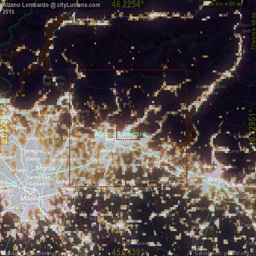
Analysis of Alzano Lombardo night lights 2016
Square area 10x10 km:
 20.91%
90-99
13.79%80-89
3.64%70-79
3.03%60-69
3.18%50-59
9.55%40-49
6.21%30-39
12.42%20-29
19.09%10-19
8.18%0-9
0%Square area 50x50 km:
8.92%90-99
9.68%80-89
4.3%70-79
4.88%60-69
6.84%50-59
7.23%40-49
6.56%30-39
6.91%20-29
7.37%10-19
10.63%0-9
26.69%Clear (daylight) street map image can be seen on geolist.org.
Map coordinates:
46° 13' 31.4" North, 9° 1' 23.7" East
45° 44' 12.5" North, 9° 43' 35" East
45° 14' 38" North, 10° 25' 46.2" East
Some cities around Alzano Lombardo sort by population:
• Seriate
5.7 km =3.5 mi,  181°
181°
• Nembro
2.8 km =1.7 mi,  73°
73°
• Torre Boldone
2.6 km =1.6 mi,  213°
213°
• Gorle
4.1 km =2.5 mi,  193°
193°
• Villa di Serio
1.7 km =1.1 mi,  156°
156°
• Scanzo-Rosciate
3 km =1.9 mi,  166°
166°
• Ranica
1.8 km =1.1 mi, 213°
• Pedrengo
4.6 km =2.9 mi, 171°
3183135 (p: 12,750)
Sources (retrieved 2019-11-25):
» Earth at Night: Flat Maps 2012, 2016