Valeggio sul Mincio night lights from space
Night Light of Valeggio sul Mincio (Veneto) from space (Italy) Src. Average luminocity for 10x10km area is 29.9524% and for 50x50km: 41.3263%.
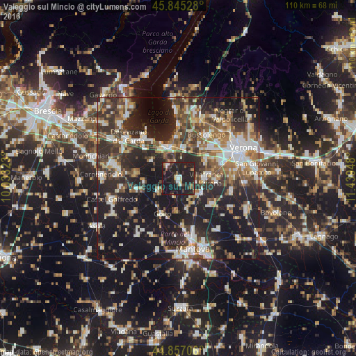
Analysis of Valeggio sul Mincio night lights 2016
Square area 10x10 km:
 2.22%
2.22%90-99
4.76%80-89
2.38%70-79
2.7%60-69
1.9%50-59
3.17%40-49
2.06%30-39
6.83%20-29
23.33%10-19
50.16%0-9
0.48%Square area 50x50 km:
6.31%90-99
8.02%80-89
3.88%70-79
4.28%60-69
5.61%50-59
6.47%40-49
6.4%30-39
7.66%20-29
15.54%10-19
28.81%0-9
7.02%Clear (daylight) street map image can be seen on geolist.org.
Map coordinates:
45° 50' 43" North, 10° 1' 59.6" East
45° 21' 12" North, 10° 44' 10.9" East
44° 51' 25.4" North, 11° 26' 22.1" East
Some cities around Valeggio sul Mincio sort by population:
• Villafranca di Verona
8.5 km =5.3 mi,  89°
89°
• Lugagnano
14.6 km =9.1 mi,  52°
52°
• Peschiera del Garda
10.3 km =6.4 mi,  337°
337°
• Sommacampagna
10.2 km =6.3 mi,  55°
55°
• Povegliano Veronese
11.3 km =7 mi, 93°
• Dossobuono
14.3 km =8.9 mi,  71°
71°
• Goito
12.8 km =8 mi,  207°
207°
• Castelnuovo del Garda
9.7 km =6 mi,  10°
10°
3164924 (p: 8,641)
Sources (retrieved 2019-11-25):
» Earth at Night: Flat Maps 2012, 2016