Porcia night lights from space
Night Light of Porcia (Friuli Venezia Giulia) from space (Italy) Src. Average luminocity for 10x10km area is 62.2991% and for 50x50km: 26.0843%.
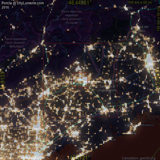
Analysis of Porcia night lights 2016
Square area 10x10 km:
 13.54%
90-99
13.69%80-89
6.1%70-79
9.08%60-69
7.44%50-59
10.42%40-49
7.74%30-39
14.58%20-29
17.41%10-19
0%0-9
0%Square area 50x50 km:
2.24%90-99
3.97%80-89
2.45%70-79
2.92%60-69
3.39%50-59
3.73%40-49
5.17%30-39
5.43%20-29
12.44%10-19
23.17%0-9
35.09%Clear (daylight) street map image can be seen on geolist.org.
Map coordinates:
46° 26' 58.6" North, 11° 54' 47.9" East
45° 57' 46.8" North, 12° 36' 59.1" East
45° 28' 19.6" North, 13° 19' 10.4" East
Some cities around Porcia sort by population:
• Pordenone
3.5 km =2.2 mi,  101°
101°
• Sacile
8.8 km =5.5 mi,  263°
263°
• Cordenons
6.9 km =4.3 mi,  70°
70°
• Azzano Decimo
7 km =4.3 mi,  148°
148°
• Fiume Veneto
10.2 km =6.3 mi,  112°
112°
• Vigonovo-Fontanafredda
6.1 km =3.8 mi,  298°
298°
• Brugnera
9.1 km =5.7 mi,  219°
219°
• Roveredo in Piano
5.1 km =3.2 mi,  2°
2°
3170154 (p: 12,987)
Sources (retrieved 2019-11-25):
» Earth at Night: Flat Maps 2012, 2016