Casarsa della Delizia night lights from space
Night Light of Casarsa della Delizia (Friuli Venezia Giulia) from space (Italy) Src. Average luminocity for 10x10km area is 33.1414% and for 50x50km: 22.2892%.
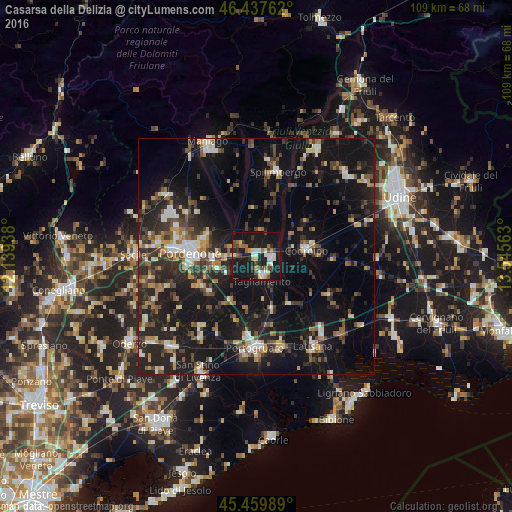
Analysis of Casarsa della Delizia night lights 2016
Square area 10x10 km:
 4.32%
4.32%90-99
5.95%80-89
2.68%70-79
3.42%60-69
4.32%50-59
2.83%40-49
7.44%30-39
2.83%20-29
7.29%10-19
55.51%0-9
3.42%Square area 50x50 km:
1.89%90-99
3.18%80-89
1.85%70-79
2.31%60-69
2.59%50-59
3.36%40-49
3.99%30-39
4.08%20-29
8.71%10-19
25.42%0-9
42.61%Clear (daylight) street map image can be seen on geolist.org.
Map coordinates:
46° 26' 15.4" North, 12° 8' 21.8" East
45° 57' 3.3" North, 12° 50' 33" East
45° 27' 35.6" North, 13° 32' 44.3" East
Some cities around Casarsa della Delizia sort by population:
• Pordenone
14.1 km =8.8 mi,  272°
272°
• Cordenons
11.6 km =7.2 mi,  288°
288°
• Rosa
3.1 km =1.9 mi,  135°
135°
• Porcia
17.5 km =10.9 mi, 274°
• Codroipo
10.7 km =6.6 mi,  81°
81°
• San Vito al Tagliamento
4 km =2.5 mi,  160°
160°
• Azzano Decimo
14.5 km =9 mi,  251°
251°
• Fiume Veneto
8.4 km =5.2 mi, 252°
3180045 (p: 8,320)
Sources (retrieved 2019-11-25):
» Earth at Night: Flat Maps 2012, 2016