Ferno night lights from space
Night Light of Ferno (Lombardy) from space (Italy) Src. Average luminocity for 10x10km area is 75.4955% and for 50x50km: 52.2894%.
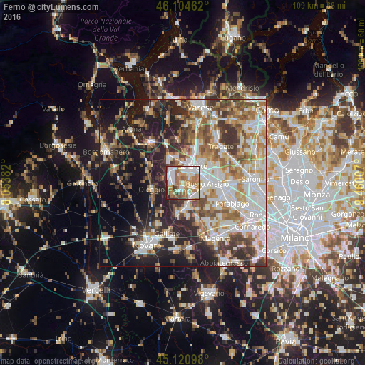
Analysis of Ferno night lights 2016
Square area 10x10 km:
 17.12%
90-99
21.67%80-89
7.73%70-79
11.21%60-69
20%50-59
9.55%40-49
3.79%30-39
4.55%20-29
4.39%10-19
0%0-9
0%Square area 50x50 km:
11.21%90-99
12.69%80-89
5.21%70-79
6.33%60-69
7.88%50-59
7.04%40-49
6.48%30-39
7.46%20-29
11.15%10-19
14.39%0-9
10.17%Clear (daylight) street map image can be seen on geolist.org.
Map coordinates:
46° 6' 16.6" North, 8° 3' 13.8" East
45° 36' 53.9" North, 8° 45' 25" East
45° 7' 15.5" North, 9° 27' 36.3" East
Some cities around Ferno sort by population:
• Busto Arsizio
7.2 km =4.5 mi,  93°
93°
• Gallarate
5.7 km =3.5 mi,  28°
28°
• Samarate
2.4 km =1.5 mi,  65°
65°
• Cardano al Campo
3.9 km =2.4 mi,  14°
14°
• Lonate Pozzolo
2.6 km =1.6 mi,  188°
188°
• Magnago
5.3 km =3.3 mi,  138°
138°
• Casorate Sempione
6.3 km =3.9 mi,  351°
351°
• Vanzaghello
4.4 km =2.7 mi,  153°
153°
3177098 (p: 6,008)
Sources (retrieved 2019-11-25):
» Earth at Night: Flat Maps 2012, 2016