Cardano al Campo night lights from space
Night Light of Cardano al Campo (Lombardy) from space (Italy) Src. Average luminocity for 10x10km area is 82.5652% and for 50x50km: 53.9327%.
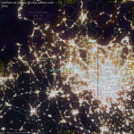
Analysis of Cardano al Campo night lights 2016
Square area 10x10 km:
 23.03%
90-99
27.27%80-89
8.48%70-79
12.12%60-69
15.61%50-59
8.18%40-49
4.24%30-39
1.06%20-29
0%10-19
0%0-9
0%Square area 50x50 km:
11.91%90-99
13.32%80-89
5.28%70-79
6.54%60-69
8.01%50-59
7.22%40-49
6.7%30-39
7.76%20-29
11.33%10-19
12.55%0-9
9.37%Clear (daylight) street map image can be seen on geolist.org.
Map coordinates:
46° 8' 17.7" North, 8° 3' 58.3" East
45° 38' 55.9" North, 8° 46' 9.6" East
45° 9' 18.7" North, 9° 28' 20.8" East
Some cities around Cardano al Campo sort by population:
• Gallarate
2.1 km =1.3 mi,  54°
54°
• Cassano Magnago
5.2 km =3.2 mi,  60°
60°
• Somma Lombardo
6.1 km =3.8 mi,  307°
307°
• Samarate
3 km =1.9 mi,  156°
156°
• Ferno
3.9 km =2.4 mi,  194°
194°
• Casorate Sempione
3.1 km =1.9 mi,  322°
322°
• Cavaria Con Premezzo
5.5 km =3.4 mi,  28°
28°
• Besnate
5.5 km =3.4 mi,  358°
358°
6534233 (p: 14,124)
Sources (retrieved 2019-11-25):
» Earth at Night: Flat Maps 2012, 2016