Dairago night lights from space
Night Light of Dairago (Lombardy) from space (Italy) Src. Average luminocity for 10x10km area is 78.2621% and for 50x50km: 60.0229%.
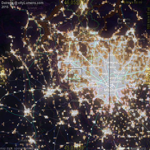
Analysis of Dairago night lights 2016
Square area 10x10 km:
 25.3%
25.3%90-99
21.21%80-89
5.3%70-79
9.85%60-69
13.79%50-59
9.7%40-49
13.64%30-39
1.21%20-29
0%10-19
0%0-9
0%Square area 50x50 km:
18.1%90-99
15%80-89
5.7%70-79
6.8%60-69
7.58%50-59
5.89%40-49
5.85%30-39
6.24%20-29
10.54%10-19
12.53%0-9
5.77%Clear (daylight) street map image can be seen on geolist.org.
Map coordinates:
46° 3' 21.2" North, 8° 9' 34.3" East
45° 33' 56.9" North, 8° 51' 45.5" East
45° 4' 17" North, 9° 33' 56.8" East
Some cities around Dairago sort by population:
• Busto Arsizio
5.2 km =3.2 mi,  348°
348°
• Legnano
5.4 km =3.4 mi,  48°
48°
• Busto Garolfo
2.5 km =1.6 mi,  141°
141°
• Canegrate
5 km =3.1 mi,  86°
86°
• Magnago
4.9 km =3 mi,  287°
287°
• San Giorgio Su Legnano
4.1 km =2.5 mi,  77°
77°
• Arconate
2.9 km =1.8 mi,  201°
201°
• Villa Cortese
1.9 km =1.2 mi, 87°
3177651 (p: 5,519)
Sources (retrieved 2019-11-25):
» Earth at Night: Flat Maps 2012, 2016