Canegrate night lights from space
Night Light of Canegrate (Lombardy) from space (Italy) Src. Average luminocity for 10x10km area is 86.6727% and for 50x50km: 67.1389%.
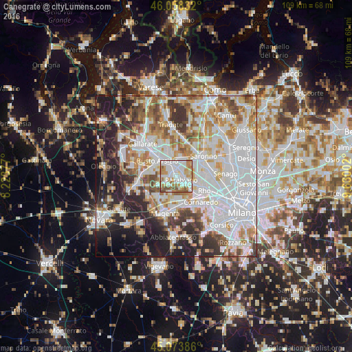
Analysis of Canegrate night lights 2016
Square area 10x10 km:
 33.48%
90-99
27.73%80-89
6.36%70-79
11.67%60-69
11.97%50-59
5.91%40-49
2.88%30-39
0%20-29
0%10-19
0%0-9
0%Square area 50x50 km:
24%90-99
16.19%80-89
6.3%70-79
7.32%60-69
8.27%50-59
5.77%40-49
5.71%30-39
5.73%20-29
9.45%10-19
8.72%0-9
2.54%Clear (daylight) street map image can be seen on geolist.org.
Map coordinates:
46° 3' 30" North, 8° 13' 25.6" East
45° 34' 5.7" North, 8° 55' 36.8" East
45° 4' 25.9" North, 9° 37' 48.1" East
Some cities around Canegrate sort by population:
• Legnano
3.4 km =2.1 mi,  344°
344°
• Parabiago
1.7 km =1.1 mi,  121°
121°
• Nerviano
4.4 km =2.7 mi,  112°
112°
• Busto Garolfo
4.1 km =2.5 mi,  236°
236°
• Cerro Maggiore
3.5 km =2.2 mi,  37°
37°
• San Vittore Olona
2.2 km =1.4 mi,  29°
29°
• San Giorgio Su Legnano
1.2 km =0.7 mi,  300°
300°
• Villa Cortese
3.1 km =1.9 mi,  266°
266°
3180852 (p: 12,322)
Sources (retrieved 2019-11-25):
» Earth at Night: Flat Maps 2012, 2016