Cortina d'Ampezzo night lights from space
Night Light of Cortina d'Ampezzo (Veneto) from space (Italy) Src. Average luminocity for 10x10km area is 7.9688% and for 50x50km: 1.3121%.
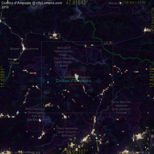
Analysis of Cortina d'Ampezzo night lights 2016
Square area 10x10 km:
 0.99%
0.99%90-99
0.14%80-89
2.7%70-79
1.28%60-69
1.7%50-59
0%40-49
0.57%30-39
0.57%20-29
1.14%10-19
0%0-9
90.91%Square area 50x50 km:
0.04%90-99
0.06%80-89
0.22%70-79
0.12%60-69
0.22%50-59
0.29%40-49
0.41%30-39
0.19%20-29
0.42%10-19
0.33%0-9
97.69%Clear (daylight) street map image can be seen on geolist.org.
Map coordinates:
47° 1' 6.3" North, 11° 26' 9.3" East
46° 32' 12.8" North, 12° 8' 20.5" East
46° 3' 3.9" North, 12° 50' 31.8" East
Some cities around Cortina d'Ampezzo sort by population:
• Belluno
44.2 km =27.5 mi,  172°
172°
• Bressanone
41.9 km =26 mi,  298°
298°
• Brunico
33.1 km =20.6 mi,  331°
331°
• Ponte nelle Alpi
41.1 km =25.5 mi,  164°
164°
• Renon - Ritten
52.1 km =32.4 mi,  270°
270°
• Valle Aurina - Ahrntal
52.5 km =32.6 mi,  346°
346°
• Sedico
48.1 km =29.9 mi,  184°
184°
• Ponte nelle Alpi-Polpet
40.2 km =25 mi, 164°
3177952 (p: 5,423)
Sources (retrieved 2019-11-25):
» Earth at Night: Flat Maps 2012, 2016