Ponte nelle Alpi night lights from space
Night Light of Ponte nelle Alpi (Veneto) from space (Italy) Src. Average luminocity for 10x10km area is 16.2386% and for 50x50km: 6.9033%.
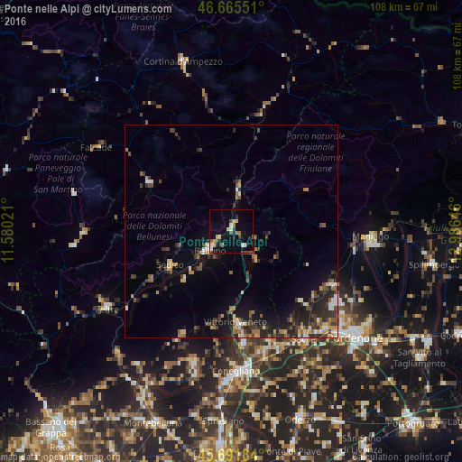
Analysis of Ponte nelle Alpi night lights 2016
Square area 10x10 km:
 1.28%
1.28%90-99
2.56%80-89
2.98%70-79
1.28%60-69
1.99%50-59
2.13%40-49
1.56%30-39
1.99%20-29
2.13%10-19
7.39%0-9
74.72%Square area 50x50 km:
0.45%90-99
0.82%80-89
0.64%70-79
0.83%60-69
1%50-59
0.98%40-49
1.28%30-39
1.72%20-29
2.43%10-19
4.17%0-9
85.68%Clear (daylight) street map image can be seen on geolist.org.
Map coordinates:
46° 39' 55.8" North, 11° 34' 48.8" East
46° 10' 51" North, 12° 16' 60" East
45° 41' 30.6" North, 12° 59' 11.3" East
Some cities around Ponte nelle Alpi sort by population:
• Belluno
6.7 km =4.2 mi,  230°
230°
• Vittorio Veneto
22.3 km =13.9 mi,  176°
176°
• Sacile
30.4 km =18.9 mi,  146°
146°
• Vigonovo-Fontanafredda
29.5 km =18.3 mi,  136°
136°
• Aviano
26.9 km =16.7 mi,  117°
117°
• Caneva
26.8 km =16.7 mi, 150°
• Sedico
16.9 km =10.5 mi,  240°
240°
• Aviano-Castello
26.3 km =16.3 mi, 118°
3170239 (p: 7,913)
Sources (retrieved 2019-11-25):
» Earth at Night: Flat Maps 2012, 2016