Corbetta night lights from space
Night Light of Corbetta (Lombardy) from space (Italy) Src. Average luminocity for 10x10km area is 70.4984% and for 50x50km: 58.7629%.
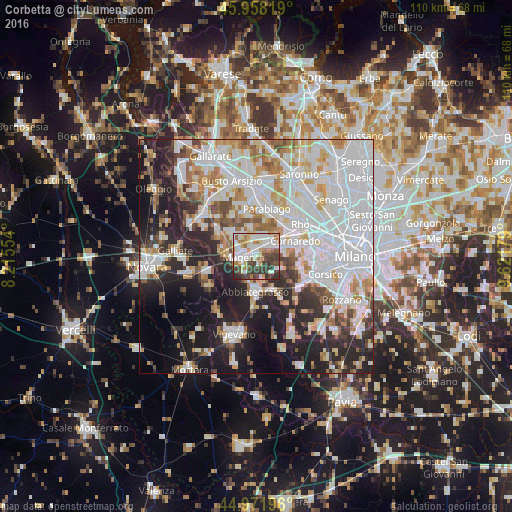
Analysis of Corbetta night lights 2016
Square area 10x10 km:
 18.41%
90-99
21.59%80-89
6.19%70-79
5.87%60-69
10.95%50-59
4.76%40-49
10.48%30-39
18.25%20-29
3.49%10-19
0%0-9
0%Square area 50x50 km:
21.61%90-99
14.15%80-89
5.14%70-79
5.73%60-69
5.96%50-59
4.2%40-49
4.37%30-39
4.51%20-29
11.59%10-19
13.93%0-9
8.81%Clear (daylight) street map image can be seen on geolist.org.
Map coordinates:
45° 57' 29.5" North, 8° 12' 55.9" East
45° 28' 2" North, 8° 55' 7.2" East
44° 58' 19.1" North, 9° 37' 18.4" East
Some cities around Corbetta sort by population:
• Abbiategrasso
7.7 km =4.8 mi,  181°
181°
• Magenta
2.7 km =1.7 mi,  263°
263°
• Bareggio
6.3 km =3.9 mi,  77°
77°
• Sedriano
4.9 km =3 mi,  57°
57°
• Arluno
4.4 km =2.7 mi,  24°
24°
• Vittuone
3.4 km =2.1 mi,  47°
47°
• Inveruno
7.5 km =4.7 mi,  313°
313°
• Casorezzo
6.3 km =3.9 mi,  347°
347°
3178125 (p: 13,801)
Sources (retrieved 2019-11-25):
» Earth at Night: Flat Maps 2012, 2016