Arluno night lights from space
Night Light of Arluno (Lombardy) from space (Italy) Src. Average luminocity for 10x10km area is 80.2016% and for 50x50km: 63.9136%.
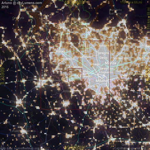
Analysis of Arluno night lights 2016
Square area 10x10 km:
 22.06%
90-99
25.56%80-89
8.89%70-79
7.94%60-69
17.14%50-59
10.79%40-49
4.92%30-39
2.7%20-29
0%10-19
0%0-9
0%Square area 50x50 km:
24.14%90-99
15.2%80-89
5.65%70-79
6.65%60-69
6.98%50-59
4.41%40-49
4.71%30-39
5.5%20-29
11%10-19
10.34%0-9
5.42%Clear (daylight) street map image can be seen on geolist.org.
Map coordinates:
45° 59' 38.7" North, 8° 14' 20.7" East
45° 30' 12.4" North, 8° 56' 32" East
45° 0' 30.6" North, 9° 38' 43.2" East
Some cities around Arluno sort by population:
• Bareggio
5.1 km =3.2 mi,  121°
121°
• Corbetta
4.4 km =2.7 mi,  204°
204°
• Sedriano
2.7 km =1.7 mi, 121°
• Vittuone
1.9 km =1.2 mi,  157°
157°
• Pogliano Milanese
5.6 km =3.5 mi,  46°
46°
• Vanzago
4.5 km =2.8 mi,  56°
56°
• Pregnana Milanese
5.2 km =3.2 mi,  74°
74°
• Casorezzo
3.8 km =2.4 mi,  304°
304°
3182835 (p: 10,362)
Sources (retrieved 2019-11-25):
» Earth at Night: Flat Maps 2012, 2016