Robbio night lights from space
Night Light of Robbio (Lombardy) from space (Italy) Src. Average luminocity for 10x10km area is 10.3841% and for 50x50km: 19.7976%.
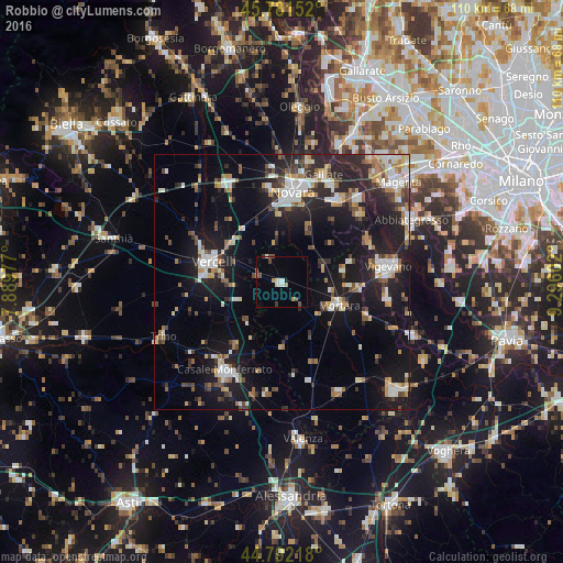
Analysis of Robbio night lights 2016
Square area 10x10 km:
 0.95%
0.95%90-99
2.22%80-89
0.95%70-79
1.75%60-69
0.48%50-59
0.63%40-49
2.86%30-39
0.95%20-29
0%10-19
0.63%0-9
88.57%Square area 50x50 km:
2.96%90-99
3.53%80-89
1.57%70-79
2.07%60-69
2.25%50-59
2.25%40-49
2.48%30-39
2.6%20-29
6.86%10-19
17.22%0-9
56.23%Clear (daylight) street map image can be seen on geolist.org.
Map coordinates:
45° 46' 53.5" North, 7° 53' 23.2" East
45° 17' 20.4" North, 8° 35' 34.4" East
44° 47' 31.8" North, 9° 17' 45.7" East
Some cities around Robbio sort by population:
• Novara
17.7 km =11 mi,  7°
7°
• Vercelli
14 km =8.7 mi,  285°
285°
• Casale Monferrato
20.5 km =12.7 mi,  212°
212°
• Trecate
19.6 km =12.2 mi,  34°
34°
• Mortara
11.8 km =7.3 mi,  111°
111°
• Cassolnovo
18.9 km =11.7 mi,  64°
64°
• Cerano
20 km =12.4 mi,  48°
48°
• Cilavegna
12.1 km =7.5 mi,  78°
78°
3169212 (p: 5,995)
Sources (retrieved 2019-11-25):
» Earth at Night: Flat Maps 2012, 2016