Rudiano night lights from space
Night Light of Rudiano (Lombardy) from space (Italy) Src. Average luminocity for 10x10km area is 34.3952% and for 50x50km: 46.6166%.
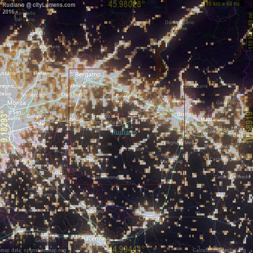
Analysis of Rudiano night lights 2016
Square area 10x10 km:
 2.86%
2.86%90-99
4.13%80-89
4.44%70-79
2.22%60-69
5.71%50-59
6.35%40-49
5.56%30-39
4.92%20-29
20.32%10-19
41.75%0-9
1.75%Square area 50x50 km:
9.09%90-99
10.19%80-89
4.53%70-79
4.82%60-69
6.59%50-59
6.88%40-49
6.4%30-39
7.52%20-29
13.69%10-19
19.41%0-9
10.88%Clear (daylight) street map image can be seen on geolist.org.
Map coordinates:
45° 58' 49" North, 9° 10' 58.5" East
45° 29' 22.3" North, 9° 53' 9.8" East
44° 59' 40" North, 10° 35' 21.1" East
Some cities around Rudiano sort by population:
• Chiari
6.2 km =3.9 mi,  30°
30°
• Orzinuovi
10.2 km =6.3 mi,  163°
163°
• Coccaglio
10.7 km =6.6 mi,  39°
39°
• Castrezzato
7.8 km =4.8 mi,  71°
71°
• Castelcovati
4.9 km =3 mi, 73°
• Pontoglio
9.2 km =5.7 mi,  344°
344°
• Soncino
10 km =6.2 mi,  187°
187°
• Trenzano
9.8 km =6.1 mi,  97°
97°
3168816 (p: 5,445)
Sources (retrieved 2019-11-25):
» Earth at Night: Flat Maps 2012, 2016