Castellaneta night lights from space
Night Light of Castellaneta (Apulia) from space (Italy) Src. Average luminocity for 10x10km area is 13.8198% and for 50x50km: 11.4993%.
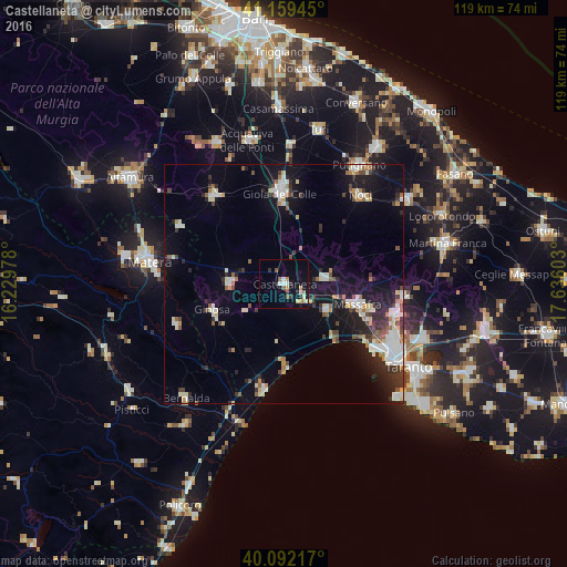
Analysis of Castellaneta night lights 2016
Square area 10x10 km:
 2.11%
2.11%90-99
1.46%80-89
1.46%70-79
2.27%60-69
1.3%50-59
2.44%40-49
0.32%30-39
1.95%20-29
2.6%10-19
5.68%0-9
78.41%Square area 50x50 km:
1.78%90-99
2.23%80-89
1%70-79
0.89%60-69
1.22%50-59
1.1%40-49
1.17%30-39
1.66%20-29
2.9%10-19
8.48%0-9
77.58%Clear (daylight) street map image can be seen on geolist.org.
Map coordinates:
41° 9' 34" North, 16° 13' 47.2" East
40° 37' 40.6" North, 16° 55' 58.4" East
40° 5' 31.8" North, 17° 38' 9.7" East
Some cities around Castellaneta sort by population:
• Massafra
16.2 km =10.1 mi,  106°
106°
• Santeramo in Colle
23.4 km =14.5 mi,  321°
321°
• Gioia del Colle
19.1 km =11.9 mi,  357°
357°
• Ginosa
15.9 km =9.9 mi,  249°
249°
• Palagiano
10.5 km =6.5 mi,  122°
122°
• Laterza
11.3 km =7 mi,  270°
270°
• Mottola
8.6 km =5.3 mi,  81°
81°
• Palagianello
4.4 km =2.7 mi, 119°
3179655 (p: 14,333)
Sources (retrieved 2019-11-25):
» Earth at Night: Flat Maps 2012, 2016