Bottanuco night lights from space
Night Light of Bottanuco (Lombardy) from space (Italy) Src. Average luminocity for 10x10km area is 79.4576% and for 50x50km: 63.7724%.
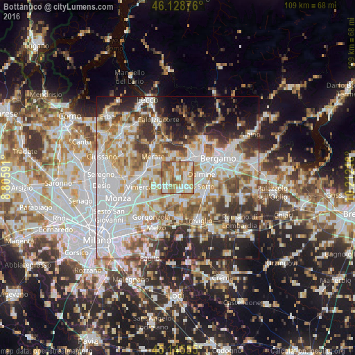
Analysis of Bottanuco night lights 2016
Square area 10x10 km:
 17.73%
90-99
21.67%80-89
7.27%70-79
17.42%60-69
24.24%50-59
8.33%40-49
3.33%30-39
0%20-29
0%10-19
0%0-9
0%Square area 50x50 km:
20.53%90-99
15.06%80-89
5.94%70-79
7.62%60-69
8.2%50-59
6.8%40-49
6.2%30-39
7.14%20-29
9.77%10-19
7.92%0-9
4.82%Clear (daylight) street map image can be seen on geolist.org.
Map coordinates:
46° 7' 43.5" North, 8° 48' 21.3" East
45° 38' 21.5" North, 9° 30' 32.5" East
45° 8' 44" North, 10° 12' 43.8" East
Some cities around Bottanuco sort by population:
• Trezzo sull'Adda
3.8 km =2.4 mi,  173°
173°
• Cornate d'Adda
3 km =1.9 mi,  245°
245°
• Capriate San Gervasio
3.4 km =2.1 mi,  151°
151°
• Terno d'Isola
5.4 km =3.4 mi,  18°
18°
• Bonate Sopra
6.1 km =3.8 mi,  39°
39°
• Brembate
5.2 km =3.2 mi,  137°
137°
• Busnago
4.3 km =2.7 mi,  234°
234°
• Bonate Sotto
5 km =3.1 mi,  50°
50°
3181668 (p: 5,121)
Sources (retrieved 2019-11-25):
» Earth at Night: Flat Maps 2012, 2016