San Giorgio delle Pertiche night lights from space
Night Light of San Giorgio delle Pertiche (Veneto) from space (Italy) Src. Average luminocity for 10x10km area is 58.2212% and for 50x50km: 54.6174%.
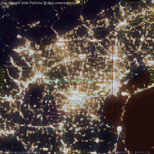
Analysis of San Giorgio delle Pertiche night lights 2016
Square area 10x10 km:
 4.39%
4.39%90-99
10.45%80-89
4.55%70-79
8.03%60-69
12.12%50-59
19.7%40-49
21.36%30-39
12.58%20-29
6.82%10-19
0%0-9
0%Square area 50x50 km:
7.45%90-99
10.03%80-89
5.81%70-79
7.23%60-69
9.84%50-59
13.05%40-49
12.34%30-39
10.89%20-29
14.2%10-19
6.59%0-9
2.58%Clear (daylight) street map image can be seen on geolist.org.
Map coordinates:
46° 1' 52.7" North, 11° 11' 27.2" East
45° 32' 27.6" North, 11° 53' 38.4" East
45° 2' 47" North, 12° 35' 49.7" East
Some cities around San Giorgio delle Pertiche sort by population:
• Campodarsego
5.2 km =3.2 mi,  155°
155°
• Mejaniga
9.3 km =5.8 mi,  174°
174°
• San Martino di Lupari
12.5 km =7.8 mi,  347°
347°
• Camposampiero
4.1 km =2.5 mi,  51°
51°
• Tombolo
12.2 km =7.6 mi,  333°
333°
• Vigodarzere
9.3 km =5.8 mi,  184°
184°
• Borgoricco-San Michele delle Badesse-Sant'Eufemia
3.7 km =2.3 mi,  99°
99°
• Limena
8.8 km =5.5 mi,  205°
205°
6535594 (p: 7,009)
Sources (retrieved 2019-11-25):
» Earth at Night: Flat Maps 2012, 2016