Besnate night lights from space
Night Light of Besnate (Lombardy) from space (Italy) Src. Average luminocity for 10x10km area is 68.6015% and for 50x50km: 49.8538%.
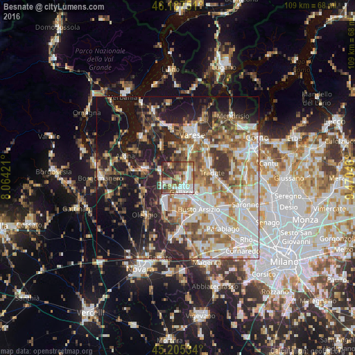
Analysis of Besnate night lights 2016
Square area 10x10 km:
 16.21%
90-99
17.73%80-89
5.91%70-79
6.82%60-69
13.64%50-59
9.85%40-49
11.36%30-39
11.82%20-29
6.67%10-19
0%0-9
0%Square area 50x50 km:
10.41%90-99
11.76%80-89
4.94%70-79
6%60-69
7.62%50-59
6.97%40-49
6.33%30-39
6.87%20-29
10.22%10-19
17.45%0-9
11.43%Clear (daylight) street map image can be seen on geolist.org.
Map coordinates:
46° 11' 15" North, 8° 3' 51.2" East
45° 41' 54.9" North, 8° 46' 2.4" East
45° 12' 19.2" North, 9° 28' 13.7" East
Some cities around Besnate sort by population:
• Gallarate
4.7 km =2.9 mi,  156°
156°
• Cassano Magnago
5.5 km =3.4 mi,  122°
122°
• Somma Lombardo
5 km =3.1 mi,  248°
248°
• Cardano al Campo
5.5 km =3.4 mi,  178°
178°
• Casorate Sempione
3.5 km =2.2 mi,  209°
209°
• Sumirago
4.4 km =2.7 mi,  16°
16°
• Cavaria Con Premezzo
2.9 km =1.8 mi,  103°
103°
• Albizzate
4.2 km =2.6 mi,  41°
41°
3182112 (p: 5,272)
Sources (retrieved 2019-11-25):
» Earth at Night: Flat Maps 2012, 2016