Albizzate night lights from space
Night Light of Albizzate (Lombardy) from space (Italy) Src. Average luminocity for 10x10km area is 62.6879% and for 50x50km: 49.9966%.
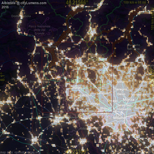
Analysis of Albizzate night lights 2016
Square area 10x10 km:
 8.03%
8.03%90-99
7.42%80-89
6.67%70-79
9.09%60-69
20.76%50-59
18.79%40-49
17.27%30-39
9.55%20-29
2.42%10-19
0%0-9
0%Square area 50x50 km:
10.87%90-99
11.9%80-89
5%70-79
6.2%60-69
7.27%50-59
6.72%40-49
6.25%30-39
6.6%20-29
9.04%10-19
18.47%0-9
11.67%Clear (daylight) street map image can be seen on geolist.org.
Map coordinates:
46° 12' 56.4" North, 8° 6' 0" East
45° 43' 37.1" North, 8° 48' 11.2" East
45° 14' 2.4" North, 9° 30' 22.5" East
Some cities around Albizzate sort by population:
• Gallarate
7.5 km =4.7 mi,  186°
186°
• Cassano Magnago
6.4 km =4 mi,  163°
163°
• Castiglione Olona
6.1 km =3.8 mi,  62°
62°
• Venegono Inferiore
7.2 km =4.5 mi,  82°
82°
• Sumirago
1.9 km =1.2 mi,  304°
304°
• Cavaria Con Premezzo
3.8 km =2.4 mi,  180°
180°
• Carnago
2.5 km =1.6 mi,  102°
102°
• Besnate
4.2 km =2.6 mi,  221°
221°
3183311 (p: 5,251)
Sources (retrieved 2019-11-25):
» Earth at Night: Flat Maps 2012, 2016