Somma Lombardo night lights from space
Night Light of Somma Lombardo (Lombardy) from space (Italy) Src. Average luminocity for 10x10km area is 50.6379% and for 50x50km: 46.1957%.
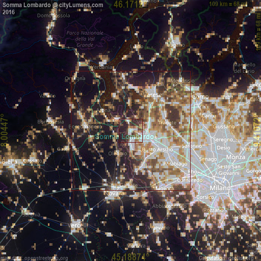
Analysis of Somma Lombardo night lights 2016
Square area 10x10 km:
 8.94%
8.94%90-99
9.85%80-89
5%70-79
4.55%60-69
5.76%50-59
8.48%40-49
10.15%30-39
11.82%20-29
25.45%10-19
10%0-9
0%Square area 50x50 km:
8.15%90-99
10.03%80-89
4.53%70-79
5.54%60-69
7.56%50-59
7.32%40-49
6.88%30-39
7.33%20-29
10.96%10-19
18.04%0-9
13.65%Clear (daylight) street map image can be seen on geolist.org.
Map coordinates:
46° 10' 16.3" North, 8° 0' 16.1" East
45° 40' 55.7" North, 8° 42' 27.3" East
45° 11' 19.5" North, 9° 24' 38.6" East
Some cities around Somma Lombardo sort by population:
• Gallarate
7 km =4.3 mi,  110°
110°
• Cardano al Campo
6.1 km =3.8 mi,  127°
127°
• Castelletto Sopra Ticino
7.1 km =4.4 mi,  306°
306°
• Sesto Calende
7.5 km =4.7 mi, 310°
• Vergiate
4.5 km =2.8 mi,  347°
347°
• Casorate Sempione
3.2 km =2 mi, 113°
• Cavaria Con Premezzo
7.5 km =4.7 mi,  81°
81°
• Besnate
5 km =3.1 mi,  68°
68°
3166409 (p: 14,851)
Sources (retrieved 2019-11-25):
» Earth at Night: Flat Maps 2012, 2016