Avetrana night lights from space
Night Light of Avetrana (Apulia) from space (Italy) Src. Average luminocity for 10x10km area is 13.4184% and for 50x50km: 15.5609%.
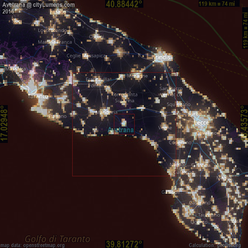
Analysis of Avetrana night lights 2016
Square area 10x10 km:
 1.19%
1.19%90-99
1.53%80-89
1.02%70-79
2.55%60-69
1.53%50-59
2.04%40-49
1.53%30-39
1.19%20-29
1.02%10-19
1.36%0-9
85.03%Square area 50x50 km:
1.6%90-99
2.36%80-89
1.84%70-79
1.56%60-69
1.9%50-59
1.5%40-49
1.51%30-39
1.48%20-29
3.15%10-19
24.63%0-9
58.45%Clear (daylight) street map image can be seen on geolist.org.
Map coordinates:
40° 53' 3.9" North, 17° 1' 46.1" East
40° 21' 2.5" North, 17° 43' 57.4" East
39° 48' 45.8" North, 18° 26' 8.6" East
Some cities around Avetrana sort by population:
• Manduria
9.7 km =6 mi,  303°
303°
• Sava
16.3 km =10.1 mi,  290°
290°
• Oria
18.3 km =11.4 mi,  335°
335°
• Veglie
19.6 km =12.2 mi,  95°
95°
• San Pancrazio Salentino
11.4 km =7.1 mi,  48°
48°
• Torre Santa Susanna
13 km =8.1 mi,  2°
2°
• Erchie
9.5 km =5.9 mi, 1°
• San Donaci
19.4 km =12.1 mi,  55°
55°
3182637 (p: 6,797)
Sources (retrieved 2019-11-25):
» Earth at Night: Flat Maps 2012, 2016