Asola night lights from space
Night Light of Asola (Lombardy) from space (Italy) Src. Average luminocity for 10x10km area is 24.397% and for 50x50km: 24.8739%.
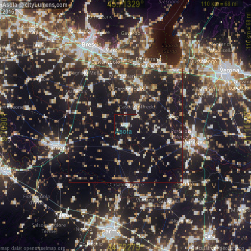
Analysis of Asola night lights 2016
Square area 10x10 km:
 2.58%
2.58%90-99
4.7%80-89
3.03%70-79
2.42%60-69
0.61%50-59
1.82%40-49
1.82%30-39
1.36%20-29
2.58%10-19
64.55%0-9
14.55%Square area 50x50 km:
2.35%90-99
3.9%80-89
2.3%70-79
2.38%60-69
3.08%50-59
2.48%40-49
3.09%30-39
4.55%20-29
10.11%10-19
35.39%0-9
30.36%Clear (daylight) street map image can be seen on geolist.org.
Map coordinates:
45° 42' 47.8" North, 9° 42' 32.4" East
45° 13' 12.6" North, 10° 24' 43.7" East
44° 43' 21.9" North, 11° 6' 55" East
Some cities around Asola sort by population:
• Castiglione delle Stiviere
19.8 km =12.3 mi,  17°
17°
• Ghedi
22.8 km =14.2 mi,  332°
332°
• Montichiari
21.5 km =13.4 mi,  357°
357°
• Carpenedolo
15.8 km =9.8 mi,  5°
5°
• Casalmaggiore
25.6 km =15.9 mi,  178°
178°
• Leno
22.5 km =14 mi,  317°
317°
• Castel Goffredo
9.5 km =5.9 mi,  30°
30°
• Goito
19.8 km =12.3 mi,  80°
80°
3182734 (p: 6,959)
Sources (retrieved 2019-11-25):
» Earth at Night: Flat Maps 2012, 2016