Carpenedolo night lights from space
Night Light of Carpenedolo (Lombardy) from space (Italy) Src. Average luminocity for 10x10km area is 45.3825% and for 50x50km: 37.1472%.
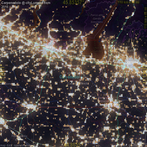
Analysis of Carpenedolo night lights 2016
Square area 10x10 km:
 8.1%
8.1%90-99
8.1%80-89
4.44%70-79
6.35%60-69
3.49%50-59
2.7%40-49
7.3%30-39
10.95%20-29
33.49%10-19
15.08%0-9
0%Square area 50x50 km:
5.8%90-99
7.33%80-89
2.98%70-79
3.56%60-69
4.53%50-59
4.97%40-49
5.89%30-39
7.39%20-29
13.37%10-19
31.83%0-9
12.34%Clear (daylight) street map image can be seen on geolist.org.
Map coordinates:
45° 51' 12.9" North, 9° 43' 41.2" East
45° 21' 42.1" North, 10° 25' 52.5" East
44° 51' 55.8" North, 11° 8' 3.7" East
Some cities around Carpenedolo sort by population:
• Desenzano del Garda
14.7 km =9.1 mi,  33°
33°
• Castiglione delle Stiviere
5.3 km =3.3 mi,  53°
53°
• Ghedi
12.9 km =8 mi,  290°
290°
• Montichiari
6.3 km =3.9 mi,  335°
335°
• Castel Goffredo
8.2 km =5.1 mi,  156°
156°
• Calcinato
10.8 km =6.7 mi,  350°
350°
• Lonato
11.6 km =7.2 mi,  18°
18°
• Asola
15.8 km =9.8 mi,  185°
185°
3180450 (p: 11,589)
Sources (retrieved 2019-11-25):
» Earth at Night: Flat Maps 2012, 2016