Sharīfābād night lights from space
Night Light of Sharīfābād (Tehrān) from space (Iran) Src. Average luminocity for 10x10km area is 64.0311% and for 50x50km: 28.4953%.
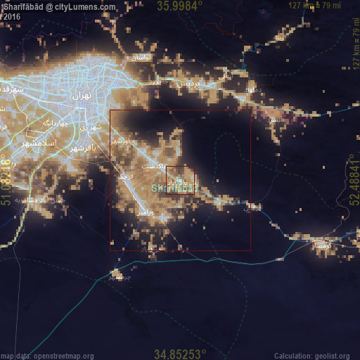
Analysis of Sharīfābād night lights 2016
Square area 10x10 km:
 2.01%
2.01%90-99
3.85%80-89
5.49%70-79
38.64%60-69
13.92%50-59
15.75%40-49
9.34%30-39
8.79%20-29
1.47%10-19
0.73%0-9
0%Square area 50x50 km:
1.99%90-99
2.41%80-89
1.46%70-79
12.04%60-69
6.05%50-59
5.27%40-49
4.76%30-39
4.18%20-29
5.66%10-19
10.68%0-9
45.5%Clear (daylight) street map image can be seen on geolist.org.
Map coordinates:
35° 59' 54.2" North, 51° 4' 55.8" East
35° 25' 39" North, 51° 47' 7" East
34° 51' 9.1" North, 52° 29' 18.3" East
Some cities around Sharīfābād sort by population:
• Tehran
44.3 km =27.5 mi,  312°
312°
• Qarchak
19 km =11.8 mi,  270°
270°
• Varāmīn
17.1 km =10.6 mi,  227°
227°
• Pīshvā
14.3 km =8.9 mi,  201°
201°
• Īstgāh-e Rāh Āhan-e Garmsār
52.2 km =32.4 mi,  114°
114°
• Eqbālīyeh
26.6 km =16.5 mi,  238°
238°
• Damāvand
41.3 km =25.7 mi,  38°
38°
• Shahrak-e Emām Ḩasan
40.4 km =25.1 mi,  279°
279°
115388 (p: 8,870)
Sources (retrieved 2019-11-25):
» Earth at Night: Flat Maps 2012, 2016