Zafarābād night lights from space
Night Light of Zafarābād (Uttar Pradesh) from space (India) Src. Average luminocity for 10x10km area is 32.0814% and for 50x50km: 18.7264%.
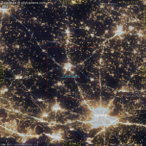
Analysis of Zafarābād night lights 2016
Square area 10x10 km:
 3.41%
3.41%90-99
4.17%80-89
0.76%70-79
2.46%60-69
3.22%50-59
2.08%40-49
9.85%30-39
14.77%20-29
19.13%10-19
25.95%0-9
14.2%Square area 50x50 km:
1.15%90-99
0.83%80-89
0.67%70-79
0.95%60-69
1.79%50-59
3.33%40-49
4.95%30-39
7.53%20-29
11.03%10-19
23.17%0-9
44.58%Clear (daylight) street map image can be seen on geolist.org.
Map coordinates:
26° 19' 50" North, 82° 1' 49.5" East
25° 41' 55.2" North, 82° 44' 0.7" East
25° 3' 48.3" North, 83° 26' 12" East
Some cities around Zafarābād sort by population:
• Jaunpur
7.7 km =4.8 mi,  322°
322°
• Bhadohi
37.5 km =23.3 mi,  205°
205°
• Shāhganj
39.3 km =24.4 mi,  352°
352°
• Machhlīshahr
32.3 km =20.1 mi,  267°
267°
• Mariāhu
16.7 km =10.4 mi,  231°
231°
• Sarāi Mīr
40.9 km =25.4 mi,  26°
26°
• Kirākat
19.5 km =12.1 mi,  110°
110°
• Barāgaon
31.1 km =19.3 mi,  164°
164°
1252702 (p: 9,106)
Sources (retrieved 2019-11-25):
» Earth at Night: Flat Maps 2012, 2016