Sarāi Mīr night lights from space
Night Light of Sarāi Mīr (Uttar Pradesh) from space (India) Src. Average luminocity for 10x10km area is 28.9187% and for 50x50km: 23.7691%.
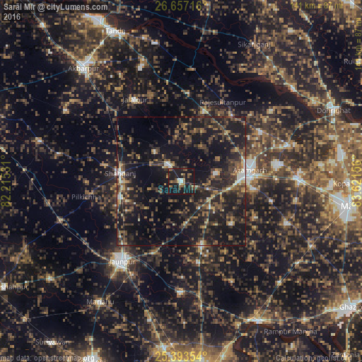
Analysis of Sarāi Mīr night lights 2016
Square area 10x10 km:
 1.98%
1.98%90-99
2.78%80-89
1.98%70-79
2.18%60-69
3.97%50-59
8.13%40-49
5.56%30-39
2.78%20-29
10.32%10-19
54.76%0-9
5.56%Square area 50x50 km:
0.94%90-99
1.71%80-89
1.38%70-79
1.99%60-69
3.12%50-59
4.49%40-49
6.46%30-39
7.76%20-29
12.33%10-19
28.94%0-9
30.88%Clear (daylight) street map image can be seen on geolist.org.
Map coordinates:
26° 39' 25.8" North, 82° 12' 55.1" East
26° 1' 37.4" North, 82° 55' 6.3" East
25° 23' 36.7" North, 83° 37' 17.6" East
Some cities around Sarāi Mīr sort by population:
• Azamgarh
26.9 km =16.7 mi,  80°
80°
• Shāhganj
23.5 km =14.6 mi,  276°
276°
• Mehnagar
25.7 km =16 mi,  129°
129°
• Nizāmābād
14.2 km =8.8 mi, 78°
• Bilariāganj
36.1 km =22.4 mi,  58°
58°
• Atraulia
34.2 km =21.3 mi,  4°
4°
• Phūlpur
7.1 km =4.4 mi,  323°
323°
• Bishunpur Urf Mahārājganj
32.5 km =20.2 mi,  37°
37°
1257260 (p: 17,849)
Sources (retrieved 2019-11-25):
» Earth at Night: Flat Maps 2012, 2016