Valpoy night lights from space
Night Light of Valpoy (Goa) from space (India) Src. Average luminocity for 10x10km area is 13.1255% and for 50x50km: 16.8261%.
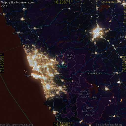
Analysis of Valpoy night lights 2016
Square area 10x10 km:
100  0%
0%
90-99 2.6%
80-89 1.08%
70-79 1.95%
60-69 0.87%
50-59 2.16%
40-49 0.43%
30-39 1.73%
20-29 5.41%
10-19 14.29%
0-9 69.48%
0%90-99
2.6%80-89
1.08%70-79
1.95%60-69
0.87%50-59
2.16%40-49
0.43%30-39
1.73%20-29
5.41%10-19
14.29%0-9
69.48%Square area 50x50 km:
100 0.88%
90-99 2.47%
80-89 2.22%
70-79 2.13%
60-69 3.83%
50-59 5.93%
40-49 3.62%
30-39 2.61%
20-29 2.71%
10-19 5.6%
0-9 67.99%
0.88%90-99
2.47%80-89
2.22%70-79
2.13%60-69
3.83%50-59
5.93%40-49
3.62%30-39
2.61%20-29
2.71%10-19
5.6%0-9
67.99%Clear (daylight) street map image can be seen on geolist.org.
Map coordinates:
16° 12' 31.4" North, 73° 26' 0.9" East
15° 31' 56.6" North, 74° 8' 12.2" East
14° 51' 13.9" North, 74° 50' 23.4" East
Some cities around Valpoy sort by population:
• Ponda
19.4 km =12.1 mi,  222°
222°
• Dicholi
21.5 km =13.4 mi,  288°
288°
• Curti
18.2 km =11.3 mi, 224°
• Navelim
16.4 km =10.2 mi,  270°
270°
• Sanquelim
14.2 km =8.8 mi,  284°
284°
• Carapur
16.5 km =10.3 mi, 283°
• Jua
20 km =12.4 mi, 269°
• Palle
9.3 km =5.8 mi, 218°
1253471 (p: 8,330)
Sources (retrieved 2019-11-25):
» Earth at Night: Flat Maps 2012, 2016