Ponda night lights from space
Night Light of Ponda (Goa) from space (India) Src. Average luminocity for 10x10km area is 59.961% and for 50x50km: 37.1337%.
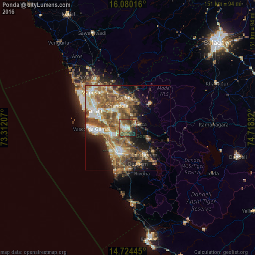
Analysis of Ponda night lights 2016
Square area 10x10 km:
100  6.06%
6.06%
90-99 12.34%
80-89 7.14%
70-79 6.49%
60-69 13.42%
50-59 21.21%
40-49 10.82%
30-39 11.04%
20-29 7.79%
10-19 3.68%
0-9 0%
6.06%90-99
12.34%80-89
7.14%70-79
6.49%60-69
13.42%50-59
21.21%40-49
10.82%30-39
11.04%20-29
7.79%10-19
3.68%0-9
0%Square area 50x50 km:
100 3.68%
90-99 7.63%
80-89 5.34%
70-79 4.81%
60-69 7.45%
50-59 9.65%
40-49 6.96%
30-39 4.55%
20-29 6.15%
10-19 8.92%
0-9 34.85%
3.68%90-99
7.63%80-89
5.34%70-79
4.81%60-69
7.45%50-59
9.65%40-49
6.96%30-39
4.55%20-29
6.15%10-19
8.92%0-9
34.85%Clear (daylight) street map image can be seen on geolist.org.
Map coordinates:
16° 4' 48.6" North, 73° 18' 43.5" East
15° 24' 12.3" North, 74° 0' 54.7" East
14° 43' 28" North, 74° 43' 6" East
Some cities around Ponda sort by population:
• Sancoale
12.3 km =7.6 mi,  256°
256°
• Curti
1.5 km =0.9 mi,  6°
6°
• Bandora
3.7 km =2.3 mi,  278°
278°
• Raia
11.9 km =7.4 mi,  203°
203°
• Cortalim
11.4 km =7.1 mi,  269°
269°
• Queula
3.5 km =2.2 mi,  245°
245°
• Goa Velha
14.6 km =9.1 mi,  287°
287°
• Palle
10.1 km =6.3 mi,  46°
46°
1259429 (p: 18,898)
Sources (retrieved 2019-11-25):
» Earth at Night: Flat Maps 2012, 2016