Jua night lights from space
Night Light of Jua (Goa) from space (India) Src. Average luminocity for 10x10km area is 66.461% and for 50x50km: 35.4494%.
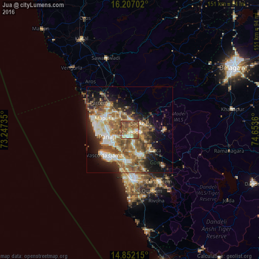
Analysis of Jua night lights 2016
Square area 10x10 km:
100  5.19%
5.19%
90-99 12.12%
80-89 11.04%
70-79 6.49%
60-69 14.94%
50-59 38.53%
40-49 9.96%
30-39 1.73%
20-29 0%
10-19 0%
0-9 0%
5.19%90-99
12.12%80-89
11.04%70-79
6.49%60-69
14.94%50-59
38.53%40-49
9.96%30-39
1.73%20-29
0%10-19
0%0-9
0%Square area 50x50 km:
100 3.67%
90-99 7.66%
80-89 4.95%
70-79 3.86%
60-69 7.13%
50-59 8.72%
40-49 6.22%
30-39 4.58%
20-29 6.51%
10-19 10.16%
0-9 36.54%
3.67%90-99
7.66%80-89
4.95%70-79
3.86%60-69
7.13%50-59
8.72%40-49
6.22%30-39
4.58%20-29
6.51%10-19
10.16%0-9
36.54%Clear (daylight) street map image can be seen on geolist.org.
Map coordinates:
16° 12' 25.3" North, 73° 14' 50.5" East
15° 31' 50.5" North, 73° 57' 1.7" East
14° 51' 7.7" North, 74° 39' 13" East
Some cities around Jua sort by population:
• Dicholi
7 km =4.3 mi,  355°
355°
• Navelim
3.5 km =2.2 mi,  85°
85°
• Sanquelim
7.2 km =4.5 mi,  58°
58°
• Serula
11.6 km =7.2 mi,  279°
279°
• Aldona
10.7 km =6.6 mi,  310°
310°
• Goa Velha
11.9 km =7.4 mi,  215°
215°
• Carapur
5.5 km =3.4 mi,  45°
45°
• Bambolim
12.8 km =8 mi,  234°
234°
1268806 (p: 5,470)
Sources (retrieved 2019-11-25):
» Earth at Night: Flat Maps 2012, 2016