Curti night lights from space
Night Light of Curti (Goa) from space (India) Src. Average luminocity for 10x10km area is 61.684% and for 50x50km: 37.2302%.
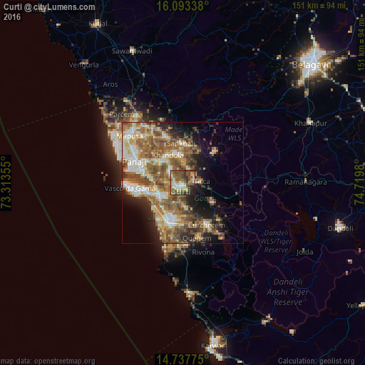
Analysis of Curti night lights 2016
Square area 10x10 km:
100  6.06%
6.06%
90-99 12.34%
80-89 8.66%
70-79 7.58%
60-69 11.69%
50-59 21.65%
40-49 13.42%
30-39 11.69%
20-29 5.41%
10-19 1.52%
0-9 0%
6.06%90-99
12.34%80-89
8.66%70-79
7.58%60-69
11.69%50-59
21.65%40-49
13.42%30-39
11.69%20-29
5.41%10-19
1.52%0-9
0%Square area 50x50 km:
100 3.66%
90-99 7.68%
80-89 5.38%
70-79 4.73%
60-69 7.63%
50-59 9.7%
40-49 6.93%
30-39 4.52%
20-29 6.18%
10-19 8.79%
0-9 34.8%
3.66%90-99
7.68%80-89
5.38%70-79
4.73%60-69
7.63%50-59
9.7%40-49
6.93%30-39
4.52%20-29
6.18%10-19
8.79%0-9
34.8%Clear (daylight) street map image can be seen on geolist.org.
Map coordinates:
16° 5' 36.2" North, 73° 18' 48.8" East
15° 25' 0" North, 74° 1' 0" East
14° 44' 15.9" North, 74° 43' 11.3" East
Some cities around Curti sort by population:
• Ponda
1.5 km =0.9 mi,  186°
186°
• Sancoale
12.9 km =8 mi,  250°
250°
• Bandora
3.9 km =2.4 mi,  256°
256°
• Navelim
13.5 km =8.4 mi,  344°
344°
• Raia
13.3 km =8.3 mi,  201°
201°
• Cortalim
11.7 km =7.3 mi, 262°
• Queula
4.5 km =2.8 mi,  228°
228°
• Palle
9.1 km =5.7 mi,  52°
52°
1273784 (p: 13,662)
Sources (retrieved 2019-11-25):
» Earth at Night: Flat Maps 2012, 2016