Palle night lights from space
Night Light of Palle (Goa) from space (India) Src. Average luminocity for 10x10km area is 27.2554% and for 50x50km: 27.9789%.
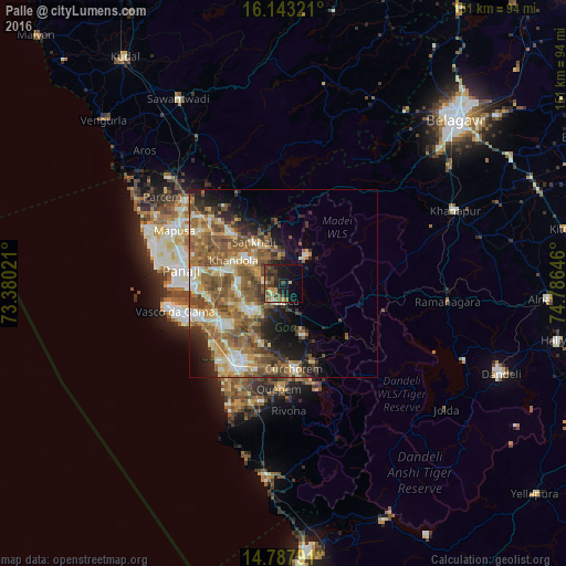
Analysis of Palle night lights 2016
Square area 10x10 km:
100  0%
0%
90-99 1.95%
80-89 2.16%
70-79 5.84%
60-69 1.52%
50-59 9.09%
40-49 6.28%
30-39 9.74%
20-29 8.44%
10-19 25.54%
0-9 29.44%
0%90-99
1.95%80-89
2.16%70-79
5.84%60-69
1.52%50-59
9.09%40-49
6.28%30-39
9.74%20-29
8.44%10-19
25.54%0-9
29.44%Square area 50x50 km:
100 1.89%
90-99 4.99%
80-89 4%
70-79 3.69%
60-69 6.42%
50-59 8.28%
40-49 5.57%
30-39 3.74%
20-29 4.74%
10-19 7.79%
0-9 48.91%
1.89%90-99
4.99%80-89
4%70-79
3.69%60-69
6.42%50-59
8.28%40-49
5.57%30-39
3.74%20-29
4.74%10-19
7.79%0-9
48.91%Clear (daylight) street map image can be seen on geolist.org.
Map coordinates:
16° 8' 35.6" North, 73° 22' 48.8" East
15° 28' 0" North, 74° 4' 60" East
14° 47' 16.5" North, 74° 47' 11.3" East
Some cities around Palle sort by population:
• Ponda
10.1 km =6.3 mi,  226°
226°
• Curti
9.1 km =5.7 mi, 232°
• Bandora
12.7 km =7.9 mi,  239°
239°
• Navelim
13 km =8.1 mi,  304°
304°
• Sanquelim
13.5 km =8.4 mi,  323°
323°
• Valpoy
9.3 km =5.8 mi,  38°
38°
• Queula
13.5 km =8.4 mi, 230°
• Carapur
15.1 km =9.4 mi, 316°
1260691 (p: 5,427)
Sources (retrieved 2019-11-25):
» Earth at Night: Flat Maps 2012, 2016