Sanquelim night lights from space
Night Light of Sanquelim (Goa) from space (India) Src. Average luminocity for 10x10km area is 52.7684% and for 50x50km: 30.0899%.
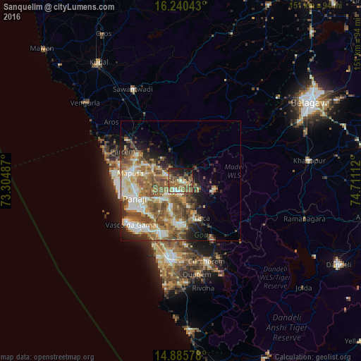
Analysis of Sanquelim night lights 2016
Square area 10x10 km:
100  3.68%
3.68%
90-99 4.76%
80-89 8.23%
70-79 8.44%
60-69 11.47%
50-59 24.68%
40-49 8.01%
30-39 6.28%
20-29 12.55%
10-19 11.26%
0-9 0.65%
3.68%90-99
4.76%80-89
8.23%70-79
8.44%60-69
11.47%50-59
24.68%40-49
8.01%30-39
6.28%20-29
12.55%10-19
11.26%0-9
0.65%Square area 50x50 km:
100 3.25%
90-99 6.61%
80-89 4.32%
70-79 3.51%
60-69 6.07%
50-59 7.83%
40-49 5.27%
30-39 3.69%
20-29 4.24%
10-19 6.58%
0-9 48.63%
3.25%90-99
6.61%80-89
4.32%70-79
3.51%60-69
6.07%50-59
7.83%40-49
5.27%30-39
3.69%20-29
4.24%10-19
6.58%0-9
48.63%Clear (daylight) street map image can be seen on geolist.org.
Map coordinates:
16° 14' 25.5" North, 73° 18' 17.5" East
15° 33' 51.2" North, 74° 0' 28.8" East
14° 53' 8.8" North, 74° 42' 40" East
Some cities around Sanquelim sort by population:
• Dicholi
7.4 km =4.6 mi,  295°
295°
• Curti
16.4 km =10.2 mi,  176°
176°
• Navelim
4.3 km =2.7 mi,  217°
217°
• Valpoy
14.2 km =8.8 mi,  104°
104°
• Aldona
14.6 km =9.1 mi,  282°
282°
• Carapur
2.2 km =1.4 mi,  274°
274°
• Jua
7.2 km =4.5 mi,  238°
238°
• Palle
13.5 km =8.4 mi,  143°
143°
1257347 (p: 11,698)
Sources (retrieved 2019-11-25):
» Earth at Night: Flat Maps 2012, 2016