Valabhīpur night lights from space
Night Light of Valabhīpur (Gujarat) from space (India) Src. Average luminocity for 10x10km area is 4.4742% and for 50x50km: 6.543%.
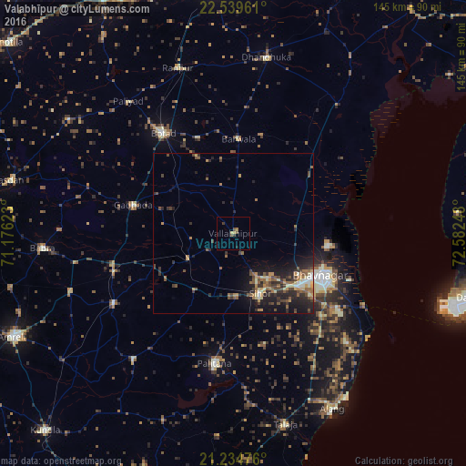
Analysis of Valabhīpur night lights 2016
Square area 10x10 km:
 0%
0%90-99
0%80-89
0.79%70-79
0.79%60-69
0.79%50-59
1.59%40-49
0.79%30-39
1.59%20-29
0.4%10-19
0.4%0-9
92.86%Square area 50x50 km:
0.2%90-99
0.58%80-89
0.89%70-79
0.89%60-69
1.08%50-59
1.59%40-49
1.27%30-39
1.29%20-29
2.77%10-19
4.6%0-9
84.85%Clear (daylight) street map image can be seen on geolist.org.
Map coordinates:
22° 32' 22.6" North, 71° 10' 34.4" East
21° 53' 19.2" North, 71° 52' 45.7" East
21° 14' 5.1" North, 72° 34' 56.9" East
Some cities around Valabhīpur sort by population:
• Bhavnagar
31.5 km =19.6 mi,  116°
116°
• Botād
38.1 km =23.7 mi,  324°
324°
• Pālitāna
40.8 km =25.4 mi,  188°
188°
• Sihor
21.5 km =13.4 mi,  156°
156°
• Gadhada
32.3 km =20.1 mi,  286°
286°
• Umrāla
9.3 km =5.8 mi,  237°
237°
• Vartej
25.4 km =15.8 mi,  130°
130°
• Dhola
11 km =6.8 mi,  265°
265°
1253512 (p: 18,663)
Sources (retrieved 2019-11-25):
» Earth at Night: Flat Maps 2012, 2016