Umrāla night lights from space
Night Light of Umrāla (Gujarat) from space (India) Src. Average luminocity for 10x10km area is 1.5298% and for 50x50km: 4.7179%.
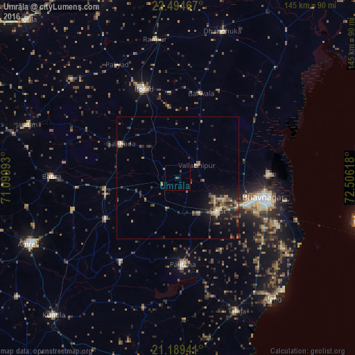
Analysis of Umrāla night lights 2016
Square area 10x10 km:
 0%
0%90-99
0%80-89
0%70-79
0%60-69
0%50-59
0.79%40-49
0.79%30-39
0%20-29
1.39%10-19
0.2%0-9
96.83%Square area 50x50 km:
0.03%90-99
0.23%80-89
0.61%70-79
0.62%60-69
0.81%50-59
1.2%40-49
1.03%30-39
1.31%20-29
1.66%10-19
3.15%0-9
89.35%Clear (daylight) street map image can be seen on geolist.org.
Map coordinates:
22° 29' 40.8" North, 71° 5' 59.7" East
21° 50' 36.7" North, 71° 48' 11" East
21° 11' 21.9" North, 72° 30' 22.2" East
Some cities around Umrāla sort by population:
• Bhavnagar
37.3 km =23.2 mi,  103°
103°
• Pālitāna
35.5 km =22.1 mi,  176°
176°
• Sihor
22 km =13.7 mi,  131°
131°
• Gadhada
27.1 km =16.8 mi,  301°
301°
• Valabhīpur
9.3 km =5.8 mi,  57°
57°
• Dāmnagar
33.9 km =21.1 mi,  240°
240°
• Vartej
29.5 km =18.3 mi,  113°
113°
• Dhola
5.2 km =3.2 mi,  323°
323°
1253815 (p: 11,874)
Sources (retrieved 2019-11-25):
» Earth at Night: Flat Maps 2012, 2016