Jhinjhāna night lights from space
Night Light of Jhinjhāna (Uttar Pradesh) from space (India) Src. Average luminocity for 10x10km area is 36.9527% and for 50x50km: 35.2996%.
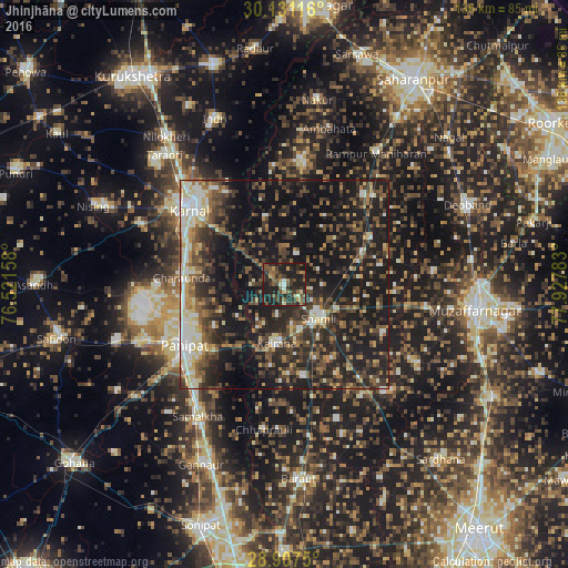
Analysis of Jhinjhāna night lights 2016
Square area 10x10 km:
 0.76%
0.76%90-99
2.27%80-89
3.03%70-79
3.79%60-69
5.68%50-59
11.93%40-49
8.14%30-39
13.45%20-29
22.54%10-19
28.41%0-9
0%Square area 50x50 km:
2.71%90-99
5.18%80-89
4.04%70-79
3.17%60-69
4.06%50-59
6.59%40-49
9.17%30-39
8.59%20-29
14.98%10-19
30.29%0-9
11.22%Clear (daylight) street map image can be seen on geolist.org.
Map coordinates:
30° 7' 52.2" North, 76° 31' 17.7" East
29° 31' 16.2" North, 77° 13' 28.9" East
28° 54' 27" North, 77° 55' 40.2" East
Some cities around Jhinjhāna sort by population:
• Shāmli
11.4 km =7.1 mi,  134°
134°
• Kairāna
14.1 km =8.8 mi,  187°
187°
• Kāndhla
22.7 km =14.1 mi,  168°
168°
• Thāna Bhawan
20 km =12.4 mi,  68°
68°
• Banat
14.1 km =8.8 mi,  116°
116°
• Ūn
7.7 km =4.8 mi,  22°
22°
• Garhi Pūkhta
8.7 km =5.4 mi, 68°
• Titron
19 km =11.8 mi,  30°
30°
1268961 (p: 19,711)
Sources (retrieved 2019-11-25):
» Earth at Night: Flat Maps 2012, 2016