Thirukattupalli night lights from space
Night Light of Thirukattupalli (Tamil Nadu) from space (India) Src. Average luminocity for 10x10km area is 1.9545% and for 50x50km: 17.0235%.
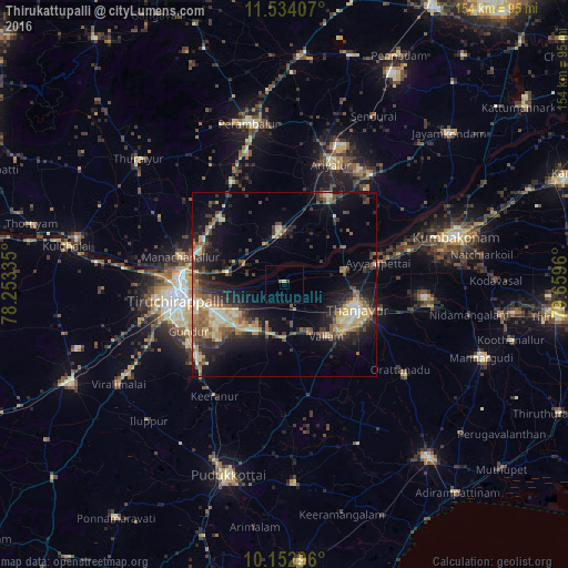
Analysis of Thirukattupalli night lights 2016
Square area 10x10 km:
 0%
0%90-99
0%80-89
0.87%70-79
0%60-69
0.43%50-59
0.43%40-49
0%30-39
0.87%20-29
0%10-19
0%0-9
97.4%Square area 50x50 km:
0.42%90-99
2.62%80-89
2.71%70-79
2.74%60-69
2.1%50-59
2.95%40-49
2.98%30-39
3.77%20-29
5.24%10-19
10.39%0-9
64.07%Clear (daylight) street map image can be seen on geolist.org.
Map coordinates:
11° 32' 2.7" North, 78° 15' 12.1" East
10° 50' 39.5" North, 78° 57' 23.3" East
10° 9' 10.7" North, 79° 39' 34.6" East
Some cities around Thirukattupalli sort by population:
• Tiruchirappalli
28.6 km =17.8 mi,  263°
263°
• Tanjore
21 km =13 mi,  108°
108°
• Ariyalūr
35.2 km =21.9 mi,  21°
21°
• Lalgudi
15.3 km =9.5 mi,  282°
282°
• Vallam
17.9 km =11.1 mi,  140°
140°
• Ayyampettāi
25.2 km =15.7 mi,  75°
75°
• Puliyūr
26.6 km =16.5 mi,  208°
208°
• Pullambādi
11.9 km =7.4 mi,  334°
334°
1254378 (p: 12,465)
Sources (retrieved 2019-11-25):
» Earth at Night: Flat Maps 2012, 2016